A new storm appeared near the East Sea
Currently, a storm with the international name Sarika is operating in the eastern Philippines.
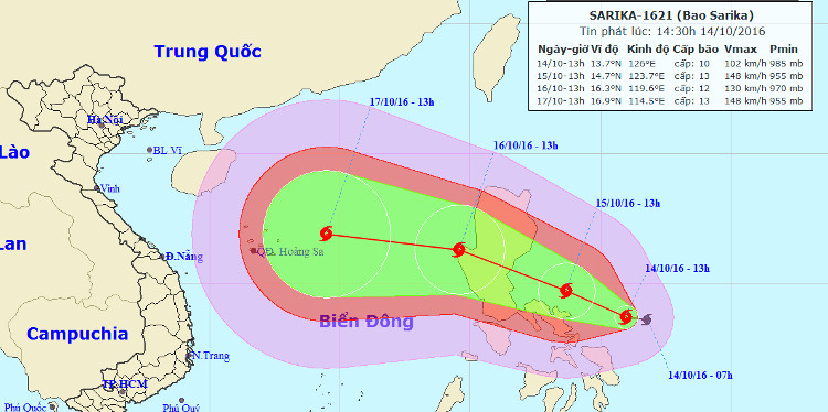
At 13 o'clock on October 14, the location of the center of the storm is about 13.7 degrees Vi Bac; 126.0 degrees Kinh Dong, about 500km from Lu Dong Island to the East Southeast. The strongest wind is in the area near the center of the storm with level 10 (90-100km / hour), level 11-12.
The path of the storm according to the storm of the Central Meteorological and Hydrography Center.
For the 24-hour forecast , the storm moves west-northwest, every hour is about 10-15km and continues to grow stronger. By 13:00 on October 15, the location of the center of the storm was about 14.7 degrees Vi Bac; 123.7 degrees Kinh Dong, 230km from Lu Dong Island to the East. The strongest winds in the area near the center of the storm are level 13, level 14-15.
In the next 24 to 48 hours , the storm moved west-northwest, each hour was 15-20 km, passing Lu Dong island into the South China Sea. At 13 o'clock on October 16, the location of the center of the storm is about 16.3 degrees Vi Bac; 119.6 degrees east longitude, on the northeast sea area of the East Sea The strongest wind in the area near the center of the storm is level 12, level 13-14.
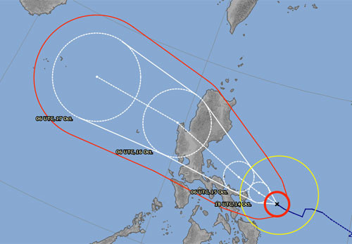
Predict the path of the storm according to Japan's meteorological station.(Photo: jma.go.jp).
Due to the impact of storms, from the morning of October 16, the East Sea in the East Sea has strong winds gradually up to level 10-11, the area near the center of the storm passes through level 12, jerks on level 12. The sea is fierce.
In the next 48 to 72 hours , the storm moved mainly in the West, about 20km per hour.
- A new storm appeared on the east sea, storm Pakhar
- A strong storm of level 14 appeared in the South China Sea
- Tin storm on the East Sea (storm No. 7)
- Storm No. 12 weakens into a tropical depression
- Hurricane Kalmaegi moves at a very fast speed
- New storm appeared on the East Sea
- Tin storm on the East Sea: Typhoon Khanun
- Storm No. 15 has not melted, near the East Sea, a new storm appears
- Typhoon Kalmaegi directly affects the North
- Typhoon Kalmaegi has entered the South China Sea, the country has scattered rain
- Storm No. 10 leaves the East Sea, still heading towards Vietnam
- 19h tonight, the storm center is located on the waters of Quang Ninh - Hai Phong
 Is the magnetic North Pole shift dangerous to humanity?
 Washington legalizes the recycling of human bodies into fertilizer
 Lightning stone - the mysterious guest
 Stunned by the mysterious sunset, strange appearance