Aere storm jerks 10-12 levels into the South China Sea
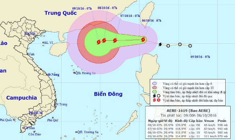
In the early morning of October 6, the tropical depression intensified into a storm, the name of which was called Aere. The strongest wind in the area near the storm center is strong at level 8 (60-75km per hour), level 11-12 when entering the East Sea.
At 08 o'clock, the location of the center of the storm is about 20.5 degrees North latitude; 120.5 degrees Kinh Dong, about 220 km from Lu Dong Island to the North. The strongest wind is in the area near the center of strong storm level 8 (60-75km / hour), level 9-10.
It is forecasted that in the next 24 hours , the storm will move in the West-Northwest direction, about 20-25km every hour, go into the South China Sea area and continue to increase. By 07:00 on October 7, the location of the center of the storm was about 20.4 degrees Vi Bac; 116.9 degrees Kinh Dong, 660km from Hoang Sa archipelago to the Northeast. Strongest winds in the area near the storm center are strong at level 9 (75-90km / h), level 10-11.
Location and path of hurricane Aere.
Dangerous zone (strong wind from level 8 or higher): North of 190N and East of Line 1150E. Disaster risk level: Level 3. Due to the impact of storms, the North East Sea in the North East Sea has strong winds of level 6-7, the area near the center of the storm passes through level 8-9, level 10-11 shock. . The sea is very strong. Disaster risk level: level 3.
In the next 24 to 48 hours , the storm moves mainly in the West, about 5km per hour and continues to increase.
By 07:00 on October 8 , the location of the storm center is about 20.4 degrees Vi Bac; 115.5 degrees east longitude, about 550km from Hoang Sa archipelago to the northeast. The strongest wind is in the area near the center of strong storm 9-10 (75-100km / hour), level 11-12 shock. Dangerous area (strong wind from level 8 or higher): North of North 180N and East of Kinh line 1140E. Disaster risk level: level 3.
Due to the impact of storms, the northern sea area of the North East Sea has strong winds of level 8, the area near the center of the storm passes through the 9-10 level, jams level 11-12. The sea is very strong. Disaster risk level: level 3.

Image of Aere storm via satellite.
In the next 48 to 72 hours , the storm has the ability to change the direction of travel in the West-South-West direction, 5km per hour and continue to increase.
In addition, due to the operation of the southwest monsoon, the middle and south of the South China Sea (including the Spratlys waters), the waters from Binh Thuan to Ca Mau, Ca Mau to Kien Giang and the Gulf of Thailand are rainy. thunderstorms with strong winds. High waves from 1.5-2.5 meters. Level 1 disaster risk level.
- Aere No. 6 storm weakens
- Aere storm entered the South China Sea
- Aere storm is unpredictable, can cause heavy rain in the mainland
- Aere storms are complicated and unpredictable
- Typhoon Doksuri approached the South China Sea, scattered thunderstorms
- Tomorrow the hot sun peaks at 38 degrees Celsius
- Storm No. 5 is directed at China
- Aere typhoon level 9-10, the East Sea has strong winds
- Hurricane number 11 advanced quickly into the South China Sea
- Storm No. 13 could change direction, targeting Central
- Emergency storm news (Storm No. 7)
- Storm No. 7 increases 2 levels when entering the East Sea
 Is the magnetic North Pole shift dangerous to humanity?
 Washington legalizes the recycling of human bodies into fertilizer
 Lightning stone - the mysterious guest
 Stunned by the mysterious sunset, strange appearance