Danas storms level 10 toward the East Sea
Early this morning (July 17), Typhoon Danas entered the northeastern coast of the island of Luke (Philippines), the strongest wind in the area near the center of strong storm level 8 (60-75km / hour), level 10 jerk.
According to the National Center for Hydro-Meteorological Forecasting, at 1h on July 17, the location of the storm center is about 17.7 degrees Vi Bac; 123.0 degrees east longitude, right on the northeast coast of Lu island (Philippines). The strongest wind in the area near the storm center is strong at level 8 (60-75km / hour), level 10 jerk.
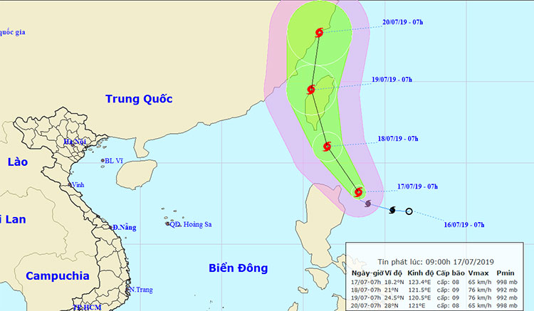
Location and movement direction of typhoon Danas.(Photo: NCHMF).
It is forecasted that in the next 24 hours , the storm will move in the northwest direction, each hour is 10-15 km and has a strong ability. At 1:00 on July 18, the location of the storm center is about 19.4 degrees Vi Bac; 121.0 degrees east longitude, right on the north coast of Lu island. The strongest wind in the area near the center of the storm is strong at level 8-9 (60-90km / hour), level 11 shock.
In the next 24 to 48 hours , the storm moves in the north-northwest direction, about 15km per hour. At 1h on July 19, the location of the storm center is about 22.0 degrees Vi Bac; 120.1 degrees east longitude, right on the southwest coast of Taiwan island. The strongest wind in the area near the center of the storm is strong at level 8-9 (60-90km / hour), level 11 shock.
In the next 48 to 72 hours , the storm moved in the north-northwest direction, about 15km per hour. At 1:00 on July 20, the location of the storm center is about 25.1 degrees North latitude; 119.1 degrees east longitude, right on the coast of Fujian province (China). The strongest wind in the area near the center of the storm is strong at level 8-9 (60-90km / hour), level 11 shock.
In the next 72 to 84 hours , the storm moved in the north, about 10-15 km every hour.
Due to the influence of the western circulation of the storm, in the Northeast Sea, the East Sea has rain; from this afternoon, the wind gradually increased to level 6-7, level 8; strong sea. Level of disaster risks due to storms on Northeastern East Sea region: level 3.
In addition, due to the strong influence of the southwest monsoon, the day and tonight (July 17), in the waters from Binh Thuan to Kien Giang, the Gulf of Thailand and the Middle and South East Sea (how including the Spratly waters) with showers and thunderstorms. During the thunderstorm there was the possibility of tornado and strong wind. The sea area from Binh Thuan to Ca Mau and the South China Sea area (including Truong Sa archipelago) has strong Southwest wind at level 5, sometimes level 6, level 8 shock. High sea waves 2.0-4.0m. The sea is rough. Level of disaster risk due to strong winds: level 1.
Occurrence of tropical depression near the South China Sea, the possibility of strong storms
- Danas and tropical depressions pose a third-degree disaster in the South China Sea
- 14-strong strong Nalgae storms towards the East Sea
- Tin storm near the east sea
- Typhoon Nari approached the waters of the central provinces
- How was the storm in the East Sea formed?
- Storm Nari threatened, many Central people evacuated
- Prohibition of boats in the Gulf of Tonkin, coping with storm No. 3
- A strong hurricane number 10 with level 12 approaches the land
- Hurricane Nida increased rapidly before entering the South China Sea
- Strong Banyan storm level 8 on the East Sea
- Tembin stormed up and landed in our country tonight
- The East Sea is about to welcome the 11th storm
 Is the magnetic North Pole shift dangerous to humanity?
 Washington legalizes the recycling of human bodies into fertilizer
 Lightning stone - the mysterious guest
 Stunned by the mysterious sunset, strange appearance