El Nino weather phenomenon may soon appear
The national weather forecast agency on 5/7 said that El Nino weather phenomenon can form in the equatorial Pacific region in the last 6 months of 2012.
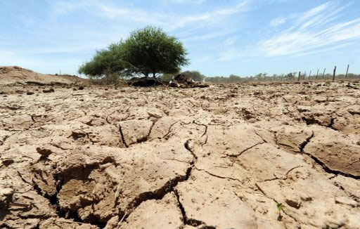
>>>Brazil: The most serious drought in the past half century
The agency's updated monthly report said the El Nino weather phenomenon could start taking place between July and September.
Accordingly, the North American region may warm up, so the Winter season will be drier than usual, while the Southwest and Southeast regions of the country may have more rain than every year.
El Nino is one of the unusual weather phenomena causing storms, floods, dryness . According to scientists, the phenomenon of En Nino will cause sea water to warm up in the winter, a few weeks before Christmas. This is a paradox of weather, but it still has a period of 3-10 years, and the phenomenon of water vapor in the sea rises even more, creating rains like falls.
The cause of this phenomenon is due to the warm water flow in the eastern Pacific Ocean moving along the countries of Chile, Peru . pushed into the air a huge amount of steam. Consequently, South American countries suffer from an unusually high rainfall of up to 15cm per day. Surprisingly, Pacific winds suddenly changed direction at the time of El Nino, blowing back to the East instead of the West as usual.
These winds are capable of passing clouds over South America, to Romania and Bulgaria, making a large area of the western hemisphere controlled by El Nino. Besides, drought phenomenon occurs in the countries of the eastern hemisphere. Because clouds are concentrated in an area with a very high density, so the rest of the world suffers from a severe drought.
Countries often suffer from dry weather caused by El Nino such as Australia, Philippines, Indonesia, Thailand, Vietnam.
- New technology to detect early El Niño phenomenon
- El Nino may stop working in the middle of this year
- El Nino 2015 looks strange with the peak of 1997
- El Nino is coming back
- Can predict the phenomenon of El Nino earlier
- El Nino is about to end in the Caribbean
- El Nino is strong record, this winter is warm
- In addition to El Nino, this is what makes the Earth hot
- El Nino can last until May 2010
- What is La Nina phenomenon?
- There is no link between El Nino and climate change
- El Nino disaster can kill millions of people globally in the future
 Is the magnetic North Pole shift dangerous to humanity?
 Washington legalizes the recycling of human bodies into fertilizer
 Lightning stone - the mysterious guest
 Stunned by the mysterious sunset, strange appearance