Hurricane Pakhar and tropical depression are
Early this morning (August 26) on the tropical convergence band, the area between the South China Sea formed a tropical depression.
New news about storm Pakhar
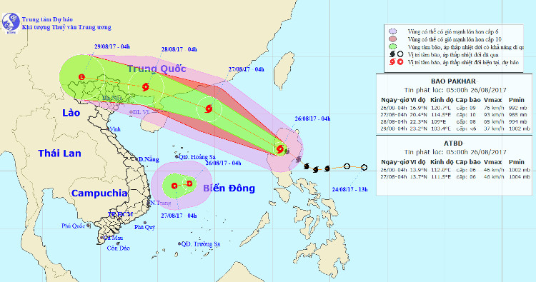
At 04:00 on August 26, the location of the storm center is about 16.9 degrees Vi Bac; 120.7 degrees Kinh Dong, on the region of Central Luzon (Philippines). The strongest wind in the area near the storm center is strong at level 9 (75-90km / hour), level 11 jerks.
It is forecasted that in the next 24 hours , the storm will move mainly in the Northwest direction, about 30km per hour. At 04:00 on August 27, the location of the center of the storm is about 20.4 degrees Vi Bac; 114.5 degrees east longitude, about 430km southeast of Lijiang Peninsula (China). The strongest wind is in the area near the center of strong storm level 10 (90-100km / hour), level 13 jerks.
In the next 24 hours , the area is dangerous (strong wind from level 6 or higher): north of the latitude 15.0 degrees North latitude; east of the meridian 112.0 degrees Kinh Dong. Disaster risk level: level 3.
Location and path of Typhoon Pakhar and tropical depression.
In the next 24 to 48 hours , the storm moved quickly in the Northwest direction, about 25km per hour. At 04:00 on August 28, the location of the center of the storm is about 22.3 degrees Vi Bac; 109.0 degrees east longitude, on the southeastern region of Guangxi province (China). The strongest wind is in the area near the center of strong storm level 8 (60-75km / hour), level 10 shock.
In the next 48 to 72 hours , the storm moved west-northwest, about 20km per hour.
Tropical depression on the East Sea
Early this morning (August 26) on the tropical convergence band, the area between the South China Sea formed a tropical depression.
At 04 o'clock, the position of the tropical depression center is about 13.9 degrees North latitude; 112.8 Kinh Dong in the area between the South China Sea. The strongest wind in the area near the center of strong tropical depression at level 6 (40-50km / hour), level 8 shock.
It is forecasted that in the next 24 hours, the tropical low pressure will move slowly in the West-South-West direction, about 5km per hour. At 04:00 on August 27, the position of the tropical depression center was about 13.7 degrees Vi Bac; 111.5 Kinh Dong, about 230km from the coast of Binh Dinh and Khanh Hoa provinces to the East. The strongest wind in the area near the center of strong tropical depression at level 6 (40-50km / hour), level 8 shock.
In the next 24 hours, the area is dangerous (strong winds of level 6 or higher, shock level 8, strong seas) from latitudes 11.0 to 17,0N; West of meridian 115,0E. Disaster risk level: level 3.
Due to the effects of tropical depressions, in the East Sea, the area between the East Sea has strong winds of level 6, shock level 8; In the South China Sea (including the waters of the Spratly Islands), the waters from Ninh Thuan to Ca Mau, Ca Mau to Kien Giang and the Gulf of Thailand have heavy showers and thunderstorms. In a thunderstorm there is a possibility of tornado and a strong wind of level 6-8. Disaster risk level: level 1.
- Image: Hurricane Pakhar devastates Binh Duong
- Hurricane Pakhar raging in HCMC
- Two people died, thousands of houses were blown away by the storm
- A new storm appeared on the east sea, storm Pakhar
- Tropical depression Kajiki weakened in the East Sea
- Washi weakened into a tropical depression
- Hurricane 4 has just weakened and appeared a tropical depression heading into the East Sea
- Typhoon Sarika weakens into a tropical depression
- Tropical depressions move quickly at sea, with the possibility of strong storms
- Storm No. 13 weakens into a tropical depression
- Tropical depressions landed on the East Sea
- Hurricane Parma challenges meteorologists
 Is the magnetic North Pole shift dangerous to humanity?
 Washington legalizes the recycling of human bodies into fertilizer
 Lightning stone - the mysterious guest
 Stunned by the mysterious sunset, strange appearance