In the morning, Typhoon Podul landed in the Central Region
Podul typhoon strengthened to level 9 with winds of 90 km / h, making it possible to land in Nghe An, Ha Tinh and Quang Binh provinces at 4-8am on August 30.
Compared to yesterday's forecast, Podul - the fourth storm in the South China Sea this year - goes faster, does not approach Hainan Island (China) but keeps a distance. By 14:00 this afternoon, the storm center of Nghe An, Quang Tri is about 380 km. Wind force level 6 or more about 120 km from the center of the storm.
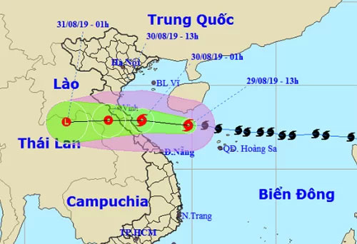
Forecast of storm path and area of Vietnam meteorological station.(Photo: NCHMF).
The National Center for Hydrometeorological Forecast says that with the speed of 20km / h, holding the west direction, around 4-8am on August 30, storms will strike Nghe An, Ha Tinh and Quang Binh, the focus will be on the area. bordering between Ha Tinh and Quang Binh, maximum wind speed of 90 km / h, level 9, jerk up 2 levels.
Meteorological Station of Japan, Hong Kong and the US Navy shared the direction and the time of the storm to land, about 7am on 30/8, maximum wind 83 km / h, level 8-9. After causing strong winds and heavy rains in Nghe An, Ha Tinh and Quang Binh, up to 13 hours the storm was in Laos, weakening into a tropical depression.
From tonight, the waters of the provinces from Thanh Hoa to Quang Tri will have stronger winds from level 6 to 8, high waves 2-5 m, very strong sea. In coastal areas of Thanh Hoa - Quang Binh provinces, the water level rises by 0.5-1 m.
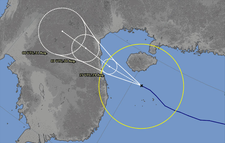
Forecasting the direction and time of landfall in the central provinces of Japan forecast station, on August 29.
International meteorological stations do not forecast storm precipitation. Particularly Accuweather (providing weather information based in the US) identified the area from Da Nang to Ha Tinh will be affected by storms with strong winds and heavy rain from the evening of August 29 to August 30, the total amount of rain from 150 to 250 mm, the highest can reach nearly 400 mm.
Vietnam Meteorological Agency said that from today to August 31, storms cause heavy rain in Central Vietnam, total rainfall is 200-400 mm. From August 30 to September 2, the rain expanded to the whole North, the total rainfall was 100-200 mm.
The Central Highlands and the South are affected by storm circulation, from today to September 1, there is heavy rain with a total rainfall of 100-250 mm.
This afternoon, Mr. Nguyen Xuan Cuong, Minister of Agriculture and Rural Development, will examine the storm response in Nghe An and Ha Tinh.
- Noon 30/8, storm No. 4 went to the mainland from Thanh Hoa to Quang Binh
- Podul storm threatened the central provinces
- Podul storm landed in Quang Binh
- Hurricane Podul, level 10, is heading into the South China Sea
- Podul storm threatened the central provinces
- Super typhoon Wutip landed in the Central region, the wind was strong
- 12th night storms landed in Central Vietnam
- Podul storm into the East Sea, the wind 60-75km / h
- Photo: Death storm Irma landed on Florida, causing casualties for Americans
- Noon 30/8, storm No. 4 went to the mainland from Thanh Hoa to Quang Binh
- Tropical depression intensified into a storm - typhoon Kai-Tak
- Cold air and circulation of storms cause heavy rain in the Central region
- Tom Tinh storms tomorrow night into Central Vietnam
- Typhoon Tembin made landfall in South Korea causing much damage
 Is the magnetic North Pole shift dangerous to humanity?
 Washington legalizes the recycling of human bodies into fertilizer
 Lightning stone - the mysterious guest
 Stunned by the mysterious sunset, strange appearance