Latest news about two tropical depressions consecutively in the South China Sea
Tropical Depression (tropical depression), known internationally as Kajiki, continues to move to the northeast and could become a typhoon in the next three days. Meanwhile, tropical depression in the South China Sea moves in the North-West Northwest direction, every hour it can travel about 10-15 km, causing strong winds of level 6 and level 8.
1. Tropical depression on land
At 10 o'clock on September 3 , the location of the tropical depression was about 15.9 degrees North; 107.3 degrees Kinh Dong, on the mainland of Thua Thien Hue provinces to Quang Nam. The strongest wind near the center of strong tropical low pressure level 6 (40-50km / h), level 8. The radius of strong wind level 6, level 8 is about 60 km from the center of tropical low pressure.
Forecast for the next 24 hours: Tropical Depression moves in the Northeast direction, every 5-10 km. By 10 o'clock on September 4, the location of tropical depression at about 16.4 degrees North latitude; 108.4 degrees Kinh Dong, on the sea off the coast from Quang Tri to Quang Nam. The strongest wind near the center of strong tropical depression is level 6-7 (40-60km / h), level 9.
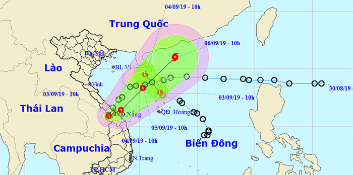
Location of 2 tropical depressions.
Over the next 24 to 48 hours , the tropical depression moves in a northeast direction, traveling about 10-15km every hour. By 10 o'clock on September 5, the location of the tropical depression was about 18.3 degrees North; 110.3 degrees Kinh Dong, right on the southern sea of Hainan Island. The strongest wind near the center of strong tropical depression is level 7 (50-60km / h), level 9.
Over the next 48 to 72 hours , tropical depressions move mainly in the northeast, traveling 15-20km every hour and likely to become a typhoon.
Warning of heavy rain: In the provinces from Nghe An to Quang Ngai, there is heavy to very heavy rain and is likely to last until September 5 (total rainfall is 300-500mm / batch, especially provinces from Ha Tinh to Thua Thien Hue 500-700mm / batch, some places over 700mm / batch); the Central Highlands region has heavy to very heavy rain (200-300mm / batch), the South has moderate rain, in some places heavy to very heavy and thunderstorms (100-150mm / wave).
2. Depression in the South China Sea
This morning, the tropical depression in the North China Sea weakened into a low pressure area.
At 10:00 on September 3 , the center of the low pressure area is about 17.9 degrees North; 111.8 degrees Kinh Dong, about 100km north of the Paracel Islands. The strongest wind in the center of the low pressure area drops below level 6 (below 40 km / h).
It is forecasted that in the next 24 hours , the low pressure area will move in the Northwest direction and further weaken.
3. Warning of strong winds and dangerous areas at sea
Warning of strong winds: During the day and tonight (March 3), in the Gulf of Tonkin region, the sea area from Quang Tri to Quang Ngai has strong winds of level 6-7, level 9 shock; high waves from 2.0 to 4.0 m; rough sea; In the coastal areas of provinces from Ha Tinh to Quang Nam, there is a strong gust of wind 7-8.
Dangerous areas in the East Sea in the next 24 hours due to tropical depressions (strong winds of level 6 or higher): North of latitude 13.0 degrees North.
In addition : Due to the strong influence of the southwest monsoon, the sea area from Binh Thuan to Ca Mau, the southern part of the South China Sea (including the Spratly Islands) has strong winds of level 7 and level 9. Ocean waves are 2.5-3.5m high. Strong seas.
Disaster risk level: level 3.
- Latest news about tropical depression
- Tropical depressions can enter the East Sea in the next 2 days
- Tropical depressions are likely to become strong storms heading into the South China Sea
- Tropical depressions may intensify into storms when approaching the Spratlys
- Tropical depression at level 8 formed in the South China Sea
- Latest news on tropical depressions in the East Sea
- Tropical depressions are gradually stronger in the South China Sea
- News of nearshore tropical depressions and tropical depressions near the East Sea
- Occurrence of tropical depression near the South China Sea, the possibility of strong storms
- Occurrence of tropical depressions in the East Sea, rainstorms all over the country
- Typhoon has just melted, tropical depressions are about to enter the South China Sea
- Tropical depressions enter the South China Sea, potentially strong into storms
 Is the magnetic North Pole shift dangerous to humanity?
 Washington legalizes the recycling of human bodies into fertilizer
 Lightning stone - the mysterious guest
 Stunned by the mysterious sunset, strange appearance