Mangkhut super typhoon weakened into tropical depression on mainland China
At 04:00 on September 17, the location of the center of the storm was about 22.6 degrees north latitude; 109.3 degrees east longitude, on land south of Guangdong province (China). The strongest wind in the area near the center of the storm is strong 9-10 (75-100km / hour), level 12 shock. Range of strong winds of level 6, level 8 or higher is about 200km from the center of the storm; Range of strong wind level 10 or higher about 70km from the center of storm.
It is forecasted that in the next 12 hours , the storm will move in the West-Northwest direction, 25-30km each hour, continue to go deep into the southern land of Guangxi province (China) and weaken into a tropical depression. By 16:00 on September 17, the position of the tropical depression center was about 24.1 degrees north latitude; 105.8 Kinh Dong, on the southern mainland of Guangxi Province (China). The strongest wind in the area near the center of the tropical depression is level 6 (40-50km / hour), level 8 shock. The level 6 strong winds, level 8 and above are about 50km from the tropical low pressure center.
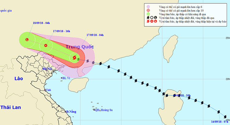
The movement direction of Typhoon Mangkhut.
In the next 12 to 24 hours , tropical depressions move in the west-northwest direction, about 25km each hour and weaken into a low pressure area, until 04 hours on September 18, the central pressure location low at about 24.8 degrees Vi Bac; 103.5 degrees east longitude, on land south of Guangxi province (China). The strongest wind in the center of the low pressure area falls below level 6 (below 40km / hour).
In the North Sea of the Tonkin Gulf (north of latitude 20.0 degrees North latitude, east of the meridian 107.5 Kinh Dong) today there are still storms, strong winds of level 6-7, level 9; high waves from 2-3m; Strong sea.
Dangerous area in the Gulf of Tonkin in the next 24 hours (strong wind level 6 or higher): North of latitude 20.0 degrees North latitude; east of the meridian 107.5 degrees east longitude.
Due to the influence of the circulation in the southwest of the storm No. 6, in Quang Ninh, Lang Son has strong winds of level 6, shock level 8; Other provinces in the North and North Central are less affected by the strong winds of storm No. 6.
Disaster risk level: level 3.
In the next 24 to 36 hours , the low pressure area moves in the West-Northwest direction, about 25km per hour is weakened and gradually dissipated on the mainland area in the southern province of Yunnan (China).
Warning of heavy rain : Due to the influence of the southwestern circulation No. 6 storm, from early morning on September 17 to September 19 in the Northeast region, there is a big to heavy rain with popular rainfall of 100-150mm, Lang Son, Cao Bang 150-200mm. Viet Bac and Northwest regions have moderate rainfall, heavy rain with 50-100mm popular rainfall, particularly Ha Giang, Lao Cai and Lai Chau with rainfall of 100-150mm. Other areas in Northern and Thanh Hoa have moderate rain and rain.
Flood warning : From 17-19 September, on the upstream of Red-Thai Binh river system, there will be a flood with a flood amplitude of 2-5m. During this flood, the flood peaks on the upper reaches of Lo, Thao, Ky Cung and Bang Giang rivers are at the level of 1, 1, 2; upstream Thai Binh river at the level of 1 level.
Warning of flash floods, landslides : High risk of flash floods, landslides in the northern mountainous provinces, especially the provinces of Quang Ninh, Lang Son, Cao Bang, Bac Kan, Ha Giang and Laos Cai, Yen Bai, Son La and Lai Chau; flooding in low-lying, low-lying areas and urban areas in the provinces of Quang Ninh, Lang Son, Cao Bang and Bac Giang.
Warning of risks of natural disasters caused by floods, flooding, landslides: level 1.
- Super Typhoon Mangkhut jumped above level 17, accelerating into the South China Sea
- Why did Mangkhut become a super typhoon in the Pacific?
- Matmo storm weakened into a tropical depression
- The vice president explained that super typhoon Mangkhut did not enter Vietnam
- Storm No. 13 weakens into a tropical depression
- Typhoon Toraji weakened into a tropical depression
- Typhoon Tembin weakened into a tropical depression
- Storm No. 6 weakened, heavy rain in Thanh Hoa - Quang Nam
- Washi weakened into a tropical depression
- Storm No. 1 enters the mainland and weakens into a low pressure
- Tropical depression Kajiki weakened in the East Sea
- Banyan storm weakened and suddenly
 Is the magnetic North Pole shift dangerous to humanity?
 Washington legalizes the recycling of human bodies into fertilizer
 Lightning stone - the mysterious guest
 Stunned by the mysterious sunset, strange appearance