Need to actively respond to typhoon Kai-Tak
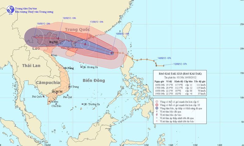
At 04:00 on August 16, the location of the center of the storm was about 19.1 degrees North latitude; 117.9 Kinh Dong, about 670km from Hoang Sa archipelago to the East North East. The strongest winds in the area near the storm center are strong at level 10, level 11 (ie from 89 to 117 km per hour), level 12 and level 13 jerks.
>>>Quang Ninh to Quang Ngai is directly affected by typhoon Kai-Tak
It is forecasted that in the next 24 hours, the storm will move in the direction of West and Northwest Northwest, each hour can travel about 20-25 km and also has a stronger ability. At 04:00 on August 17, the location of the storm center is about 20.9 degrees North latitude; 112.5 degrees Kinh Dong, about 500km from Mong Cai (Quang Ninh) to the East of Southeast. The strongest winds in the area near the storm center are strong at level 12 (ie 118 to 133 km per hour), level 13 and level 14 jerks.
Beam photos of the path and location of the storm
In the next 24 to 48 hours, the storm moves in the direction of West and West Northwest, about 20 to 25 km per hour, along the southern coast of Guangxi Province (China). By 4:00 pm on August 18, the location of the center of the storm was about 22.1 degrees north latitude; 107.0 Kinh Dong, on the border of Cao Bang - Lang Son. The strongest wind in the area near the storm center is strong at level 8 (ie 62 to 74km per hour), level 9 and level 10 jerks.
In the next 48 to 72 hours, the storm moved mainly in the West, about 20km per hour.
Due to the impact of the storm, the North Sea in the East Sea has strong winds of level 8, level 9, then increases to level 10, level 11, the area near the center of the storm passes through level 12, jerks of level 13 and level 14. Violent sea . In the North Sea of the Gulf of Tonkin from noon and late afternoon (August 17), the wind will gradually increase to level 6, level 7, near the storm center level 8, level 9, level 10, level 11. In the North Ministry from afternoon and tomorrow night has moderate rain, heavy rain to very big.
In addition, due to the strong influence of the southwest monsoon, the area between the South and the South China Sea (including the Spratlys waters), the waters from Binh Thuan to Ca Mau have strong winds of level 6, jerky. Sea level 7, level 8.
- Hanoi plans to respond to super typhoon Mangkhut
- Actively respond to hurricane Krosa
- Actively prevent storm Kai-Tak
- 'Vietnam needs to actively participate in combating climate change'
- The 10 biggest storms recorded in history
- But storms appeared in Asia: Phong Than became stronger and destroyed similarly in 2008?
- The North urgently resisted Typhoon Haiyan
- Tang love covers Tacloban
- Typhoon Haiyan is heading into Quang Ngai
- In the next 24 hours, the mind of the super typhoon Haiyan enters the waters of Hue-Binh Dinh
- Haima storm causes level 16 wind to enter the South China Sea
- 10,000 people may have died due to Typhoon Haiyan in the Philippines
 Is the magnetic North Pole shift dangerous to humanity?
 Washington legalizes the recycling of human bodies into fertilizer
 Lightning stone - the mysterious guest
 Stunned by the mysterious sunset, strange appearance