No.1 storm suddenly changed direction, can go through Hai Phong, Hanoi
Due to the impact of typhoon No. 1, Bach Long Vi island has strong winds of level 9, level 12 recoil. The coastal area from Quang Ninh to Ninh Binh has strong winds of level 5-6, shock level 7-8.
At 14 o'clock on July 27, the location of the center of the storm was about 20.0 degrees north latitude; 107.4 degrees east longitude, 100km from the coast of Thai Binh - Ninh Binh provinces to the southeast. The strongest wind is in the area near the storm center with strong level 9 (75-90km / h), level 10-12 shock.
It is forecasted that in the next 6 hours , the storm will move west-northwest, every hour is 15-20km. Thus, from this evening, the center of the storm will enter the coastal provinces of the Northern Delta, directly affecting the area from South Quang Ninh to Bac Thanh Hoa.
It is forecasted that in the next 6-12 hours, the storm will move in the West Northwest direction, each hour is 15-20km and gradually weakened into tropical depression. By 01:00 on July 28, the position of the tropical depression center was about 20.7 degrees Vi Bac; 105.9 Kinh Dong, in the center of the northern delta. The strongest wind in the area near the center of tropical low pressure is level 6-7 (40-60km / h), level 8-9.
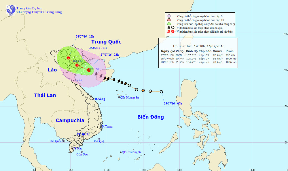
Location and path of Typhoon Mirinae.
Due to the impact of the storm after weakening into tropical depression, the waters of the Gulf of Tonkin (including Bach Long Vi, Cat Hai, Co To and Van Don districts) have strong winds of level 6-7, near the storm center level 8-9, level 10-12 jerk. The sea is very strong. The coastal areas of provinces from Quang Ninh to Thanh Hoa have strong winds of level 6-7, areas near center of storm level 8-9, level 10-11 shock. In the Northern and Thanh Hoa provinces, there is heavy rain. Warning of the risk of flash floods, landslides in mountainous areas, flooding in low-lying areas in the Northeast, Northern Delta and Viet Bac provinces. Disaster risk level: level 3.
Hanoi has strong winds of level 6, shock level 7-8 and from tonight until the end of the night, July 28, there is very heavy rain, the rainfall is about 100-200mm.
It is forecasted that in the next 12-24 hours , tropical depressions will move in the northwest direction, each hour is 15-20 km, continue to go deep into the mainland and weaken into a low pressure area. By 13:00 on July 28, the central location of the low pressure area was around 21.7 degrees Vi Bac; 104.7 degrees Kinh Dong, on the western area of the North of Vietnam. The strongest wind in the center of the low pressure area falls below level 6 (below 40km / h).
Due to the impact of the tropical depressions after weakening into low pressure areas, the provinces of Bac Bo and Thanh Hoa continue to have moderate rain and heavy rain. The total amount of rainfall in the whole period caused by the typhoon No. 1 is popular 100-200mm, there are places over 300mm. Warning of a very high risk of flash floods, landslides in mountainous areas, flooding in low-lying areas of the Northeast, the Northern Delta and Viet Bac. Disaster risk level: level 3.
In addition, in the South China Sea region (including the Spratlys waters), the offshore waters of the provinces from Binh Thuan to Ca Mau have strong winds of level 5, sometimes level 6, level 7-8 shock. The sea is rough.
- Bebinca storms can land in Hai Phong - Nghe An area
- Storm level 10 is directed at Quang Ninh - Hai Phong
- This morning, the storm started to cause rain in the Central region
- Storm No. 4 changed direction and got stronger
- Storm No. 3 is about 180km from Quang Ninh - Hai Phong
- Plants fell mass in Hanoi and Hai Phong after the storm Wipha
- Tropical depression strengthened into storm No. 2, heading to Quang Ninh - Hai Phong
- Storm No. 7 can enter Quang Ninh - Hai Phong
- Why do storms often follow the West-North direction?
- Influence of typhoon Kalmaegi, from the north there is heavy rain
- Storm No. 5 will enter Hanoi at 15-16 this afternoon
- 19h tonight, the storm center is located on the waters of Quang Ninh - Hai Phong
 Is the magnetic North Pole shift dangerous to humanity?
 Washington legalizes the recycling of human bodies into fertilizer
 Lightning stone - the mysterious guest
 Stunned by the mysterious sunset, strange appearance