Satellite images denounce climate change that changes the Earth
NASA and ESA satellites have recently sent photos to Earth in January 2018. The series continues to be a warning about global climate change.
Although scientists have measured the highest temperature in the Sahara desert on earth, it has also seen snowfall as high as 40cm.
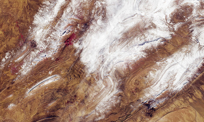
Snowfall is rare in northwest Algeria on the outskirts of the Sahara.
In the desert the night temperature often falls deep but very rarely snow falls because the air is very dry.
This is the third time in 40 years this area has recorded snowfall.
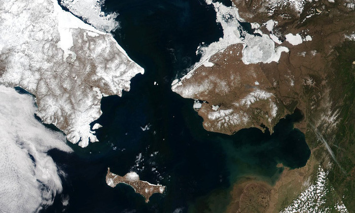
This is a picture of the narrowest part of the Bering Strait connecting Asia and America.The distance between Cape Dezhnev on the Chukutka Peninsula (Russia) and Cape Prince of Wales Cape on the Alaska (USA) board is about 82km.
If the distance between sovereignty islands is taken into account, the distance between Russia and the US is nearly unexpected, only about 3.8km - the distance between Big Diomede Island (Russia) and Little Diomede Island (USA). The two islands are clearly visible in the picture above.
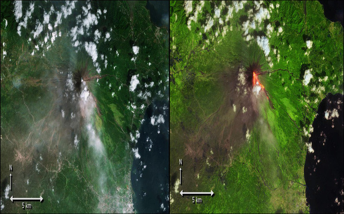
Mount Mayon on Luzon Island in the Philippines is one of the most active volcanoes in the world.
The above two pictures describe the volcano before and during the volcanic eruption. The second photo uses a false color to simulate the influence of lava sprayed from the top of Mayon.
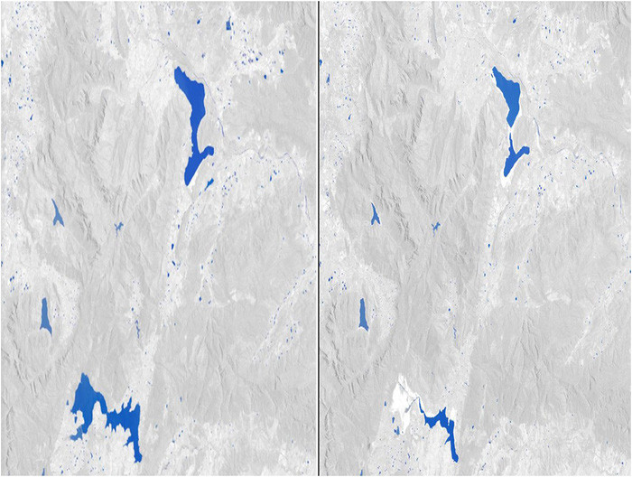
Water is increasingly depleted in Cape Town, South Africa.The picture on the left is taken in January 2014, the following photo was taken in 1/2018.The blue in the image is the lake, the rest is gray to make it easy to distinguish.
Cape Town on the west coast of South Africa is facing the risk of running out of clean water. According to the local government, with the current level of water use, only in April, all taps in the city will stop working. At that time, 3.7 million residents would have to live on one of the 200 public water supply points.
At the end of January, six important lakes in Cape Town contained only 26% of the lake. Meanwhile Theewaterskloof dam plays a role in supplying water to half of the city's residents, only 13% of the capacity. It is worth mentioning that at this time 4 years ago, the water in Theewaterskloof dam was almost full of water.
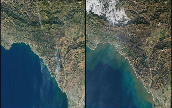
Above is a picture of before and after the double disaster of forest fires - storms and storms in California, USA.Two photos show the same location before and after Montecito in California (USA) suffered two consecutive disasters: forest fire and storms.
The first photo was taken on November 23, 2017 before the forest fire, the second was taken on January 10, 2018 after the mudslide swept.
The land of prosperity in Los Angeles turned into a devastating scene between January when mud and trash swept in, killing 18 people. The mud here is caused by heavy rain and as if "adding oil to the fire" when more than 113,000 hectares of forest were destroyed by the historic fire.
In the second photo, brown is the mud, the green is the lucky tree surviving the fire.
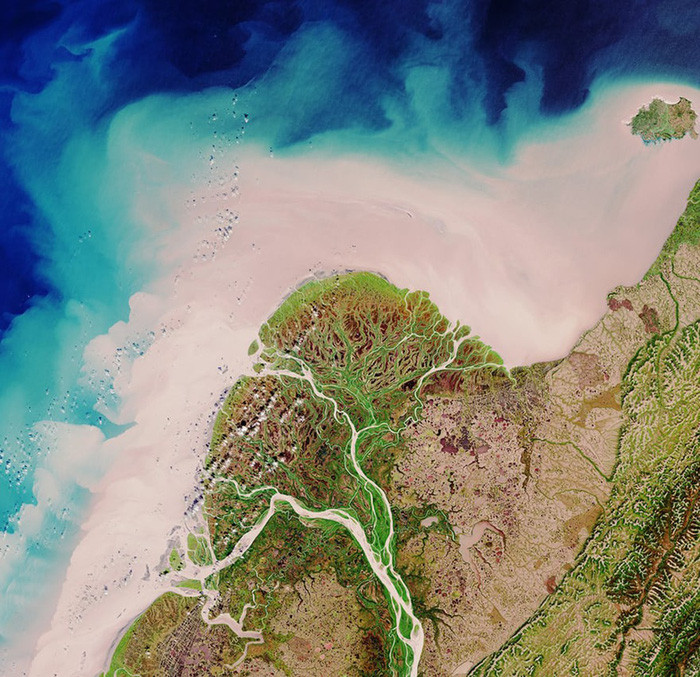
This is a picture of part of the Yukon plain in Alaska (USA).The Yukon River flows through the province of British Columbia and the Yukon Territory in Canada before entering Alaska (USA) and eventually into the Bering Sea.
The yellow soil in the picture depicts the amount of river sediment flowing into the sea at the beginning of the year.
Scientists believe that the amount of sediment has increased significantly in the decades of the permafrost of the Yukon River melting and the effects of global warming.
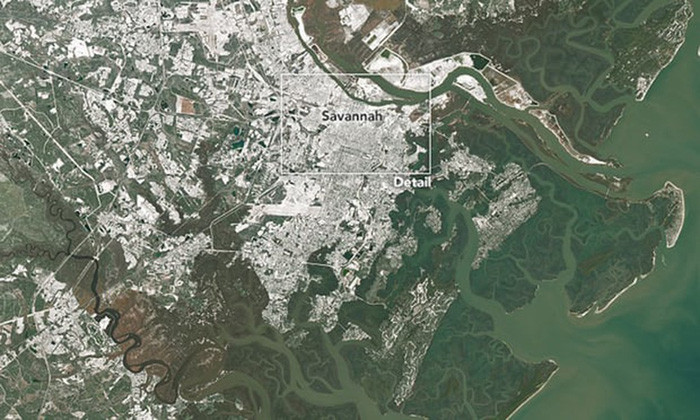
It is rare to see snow falling in Savannah, Georgia, but NASA's Landsat 8 satellite captures this image during this fierce winter this year.
According to the US National Weather Service, the area's airport snow is 3cm thick, ranking 7th in the history of snowfall during the day.
- Review NASA photos to see how terribly the Earth has changed
- US launches satellite tracking climate change
- The terrifying change of the Earth due to climate change
- NASA is about to launch a new generation earth observation satellite
- How has the earth changed during the last 100 years?
- What is Climate Change?
- Images show the Earth is gray, not blue
- Marching for climate change around the world
- Spectacular beautiful images of the Earth taken from MSG-4 satellites
- Climate change is happening faster than expected
- The transformations of the Earth through satellite images
- 4 shocking findings on climate change
 Is the magnetic North Pole shift dangerous to humanity?
 Washington legalizes the recycling of human bodies into fertilizer
 Lightning stone - the mysterious guest
 Stunned by the mysterious sunset, strange appearance