Scan online map, discovered 27 mysterious thousand-year-old temple
27 thousand-year-old monuments belonging to the legendary Maya empire, never known before, were revealed after Professor Takeshi Inomata tried to "scan" a map of the states of Tabasco and Chiapas states in Mexico last year.
The map was created using LIDAR technology , a technique that uses lasers from the air to hit the ground to record a 3D map of the ground.
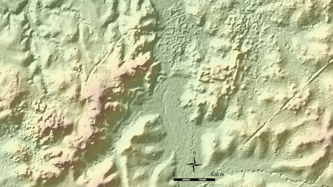
Part of an online map where mysterious Maya temples were discovered - (photo: NATIONAL STATISTICS AND GEOGRAPHY (MEXICO).
The map was uploaded to a website of the National Institute of Statistics and Geography (Mexico), recording an area of 4,400 square miles, giving users free access.
According to Professor Inomata, these are the places used to serve the Mayan rituals.
The professor, Inomata, he mapped the area because earlier, a team led by him unearthed a ceremonial complex belonging to an unknown civilization dating back to 1000-900 BC. Originally, located at Ceibal in Guatemala. They want to expand the search area, including the Mexican state of Tabasco nearby.
Professor Inomata said the new ritual site belonged to the period when the Maya began to use ceramics and led a less sedentary lifestyle. Religious activities develop and orient the lives of the people. The area is also surprisingly well planned with neat rectangles appearing on the map.
This is not the first time LIDAR technology has recorded in archeology. In early 2018, a multinational research team announced the discovery of a Mayan metropolis with 60,000 temples, large and small houses, which were revealed by LIDAR after thousands of years hidden by Guatemalan old forests.
Most recently, 1,000 prehistoric structures belonging to many periods, no one ever knew on a Scottish island - United Kingdom was also revealed thanks to LIDAR.
- Discovered a thousand-year-old Cham temple complex
- The thousand-year-old cat mummy has 5 legs and 3 tails
- Discovered a 6000-year-old ancient temple in Ukraine
- Mystery of temples 'timeless' in India: There is a value of up to 100 billion USD!
- Discovered 3,000-year-old megalithic temple in Peru
- The mystery of the thousand-year lights does not turn off
- Mexico unearthed the temple of wind gods under the supermarket nail
- A thousand-year-old gold mummy like the one who lives in China
- The mysterious 'Pyramid' in Indonesia
- Mysterious temple in India is carved from a single stone block
- Discovered 3 tombs located deep in the Temple of Mysterious Snakes
- Sacrifice ceremony through the newly discovered ancient temple
 Discovered an ancient centipede fossil 99 million years old
 Discovered bat-like dinosaurs in China
 Discovered a 200-year-old bronze cannon of the coast
 Discover 305 million-year-old spider fossils