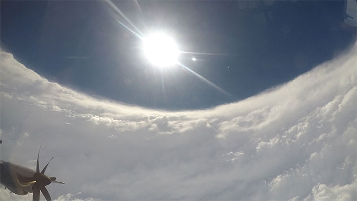
Stadium effect in Dorian's eye
The stadium effect in the eye of the storm reveals the power of Dorian on the way to the Bahamas.
The US National Hurricane Center shared photos as scientists of the Oceanic and Atmospheric Administration (NOAA) flew past the eye area of Typhoon Dorian on Sept. 1. They found Dorian became very powerful with the stadium effect in the center of the storm .
The plane flies over the eye of the storm.(Photo: NHC).
The stadium effect makes the eye of the storm look like the dome of a sports stands. Outside the clear central part of the dome are the most violent winds. This effect occurs when columns of air rising high rapidly swirl and spread around from the center of the storm. As a result, the eye becomes bigger as the altitude of the storm rises, according to the Washington Post.
Typhoon Dorian swept the Bahamas in the afternoon of September 1 with a gust of more than 320km / h, destroying many homes and businesses, causing floods and killing at least 5 people. Dorian weakened to level 4 in the US fifth rank after landing in the Bahamas.
The predicted Dorian storm will hit coastal Florida and Georgia on September 3 and September 4, then sweep across South Carolina and North Carolina on September 5. The storm will only be a tertiary strength when approaching the east coast of Florida. The biggest threat to people in the state is gusts of up to 128km / h and storm surges.
- What is a storm? How are storms formed and why are they storms?
- Did you know: Who named the tropical storm?
- Little-known secret about the stadium opening the 2018 World Cup
- The video showcases the stunning stadiums for the Qatar 2022 World Cup
- Stadium effect in the eye of storm
- The first stadium in the world equipped with air conditioning
- Stadium creates electricity through the sun
- Build stadium football from ... container
- How was the bustling atmosphere in the stadium created?
- Technical requirements for World Cup stadium
- Underground stadium
- Video: The world's first wooden stadium
- Discover interesting psychological effects
- Forest in the football field
 Is the magnetic North Pole shift dangerous to humanity?
 Washington legalizes the recycling of human bodies into fertilizer
 Lightning stone - the mysterious guest
 Stunned by the mysterious sunset, strange appearance