Storm Nalgae heads straight to North Central
At 04:00 on October 3, the location of the center of the storm was about 17.6 degrees north latitude; 114.7 degrees Kinh Dong, about 250 km from Hoang Sa archipelago to the East Northeast. The strongest winds in the area near the storm center are strong at level 10, level 11 (ie from 89 to 117 km per hour), level 12 and level 13 jerks.
It is forecasted that in the next 24 hours, the storm will move in the direction of West and Northwest Northwest, about 10 - 15 km per hour. At 04:00 on October 4, the location of the storm center is about 18.0 degrees north latitude; 111.8 Kinh Dong, on the northern area of Hoang Sa archipelago. The strongest winds in the area near the storm center are strong at level 10, level 11 (ie from 89 to 117 km per hour), level 12 and level 13 jerks.
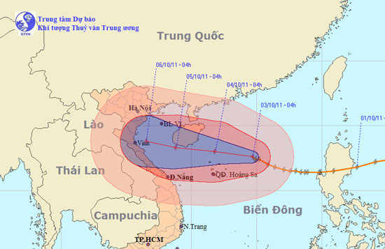
The location and direction of the storm. (Click on image to view larger size)
In the next 24 to 48 hours, the storm moves in the direction of West and West Northwest, about 10 - 15km per hour. At 04:00 on October 5, the location of the storm center is about 18.3 degrees Vi Bac; 108.8 Kinh Dong, on the southwestern area of Hainan Islands (China), about 250km from Nghe An - Thua Thien Hue coast to the East. The strongest winds in the area near the storm center are strong at level 10, level 11 (ie from 89 to 117 km per hour), level 12 and level 13 jerks.
In the next 48 to 72 hours, the storm moved west-northwest, about 10 to 15 km per hour.
Due to the impact of storms, the North East Sea area (including the Paracel Islands) has strong winds of level 9, level 10, the area near the center of the storm passes through level 11, level 12, shock level 13, level 14 The sea is rough.
In addition, due to the influence of cold air combined with the circulation of typhoon No. 6 in the Gulf of Tonkin, there is strong northeast wind at level 6, level 7, level 8 shock.
- Storm Nalgae reduced to level 10
- Storm Nalgae melts at sea
- No. 6 hurricane weakens,
- Storm No. 6 weakened, heavy rain in Thanh Hoa - Quang Nam
- Thunderstorm storms straight into Quang Ninh
- Typhoon Krosa is strong up to level 15, going straight to the Central
- Mujigae storms move faster and stronger
- The Philippines struggled with the consequences of two storms
- Suddenly No. 6 storm
- Typhoon No. 4 weakened, the North and the North Central region had heavy heavy rain
- Tin storm near the East Sea: Typhoon Bailu, North and North Central thunderstorms
- Hot sun returns to the North and Central
 Is the magnetic North Pole shift dangerous to humanity?
 Washington legalizes the recycling of human bodies into fertilizer
 Lightning stone - the mysterious guest
 Stunned by the mysterious sunset, strange appearance