Storm No. 12 constantly changes direction
At 04:00 on November 2, the location of the center of the storm was about 19.4 degrees North latitude; 116.0 degrees Kinh Dong, about 510 km from Hoang Sa archipelago to the East of the Northeast. The strongest wind in the area near the center of the storm is strong at level 12, level 13 (ie from 118 to 149km per hour), level 14, level 15.
It is forecasted that in the next 24 hours, the storm will move mainly in the West, then it is possible to change the direction of traveling in the West-South-West direction, about 15km per hour. At 04:00 on November 3, the location of the storm center is about 18.8 degrees Vi Bac; 112.4 degrees Kinh Dong, about 230km from Hoang Sa archipelago to the North. The strongest wind in the area near the center of the storm is strong at level 12, level 13 (ie from 118 to 149km per hour), level 14, level 15.
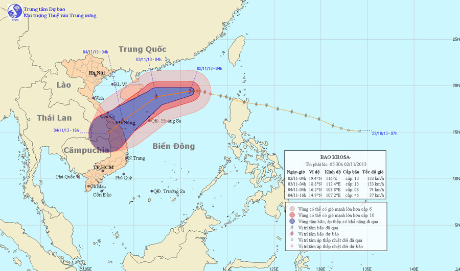
Photo of the path and location of hurricane Krosa
In the next 24 to 48 hours, the storm has the ability to change the direction of travel in the direction between Western Southwest and Southwest, each hour is about 15-20 km. At 04:00 on November 4, the location of the storm center is about 16.2 degrees Vi Bac; 108.8 degrees Kinh Dong, right on the waters of Quang Tri - Quang Ngai provinces. The strongest winds in the area near the storm center are strong at level 8 (ie 62 to 74km per hour), level 9 and level 10 jerks.
In the next 48 to 60 hours, the storm continued to move in the direction between Southwest Southwest and Southwest, about 15km per hour.
Due to the influence of typhoons, the North East Sea region (including the northeastern sea area of the Paracel Islands) has strong winds of level 8 - 10, the area near the center of the storm passes through 11-13 levels, level 14 jerks , level 15. The sea is rough.
- Why do storms often follow the West-North direction?
- 'Strange' path of storm No. 4
- Storm No. 13 could change direction, targeting Central
- Storm No. 7 constantly changed direction, the sea was very strong
- This morning, the storm started to cause rain in the Central region
- Storm No. 13 is approaching the Paracel Islands
- Storm No. 4 changed direction and got stronger
- Storm No. 12 is gradually stronger, heading straight to Khanh Hoa - Ninh Thuan
- Influence of typhoon Kalmaegi, from the north there is heavy rain
- Tropical depression strengthened into storm No. 2, heading to Quang Ninh - Hai Phong
- Storm No. 4: Constantly calling for shelter boats
- A new storm appeared on the east sea, storm Pakhar
 Is the magnetic North Pole shift dangerous to humanity?
 Washington legalizes the recycling of human bodies into fertilizer
 Lightning stone - the mysterious guest
 Stunned by the mysterious sunset, strange appearance