Storm No. 6 weakened, the North will have heavy rain
Due to the impact of the 12th strong storm off the Pacific, hurricane 6 moved more slowly than expected. On August 6, the storm weakened into a tropical depression and headed to Quang Ninh province.
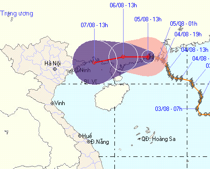
According to the Central Center for Meteorological and Hydrological Forecasting, No. 6 storm (Goni) moves very little. On the afternoon of August 5, this level 10 gale storm still raged on the southern coast of Guangdong Province (China).
In the next 2 days, the storm No. 6 moves slowly in the West, weakening into a tropical depression.
Goni's " dignity " challenges many forecasting agencies of Vietnam and the world. (Photo: NCHMF)
According to Mr. Le Thanh Hai, Deputy Director of the Center, due to the interaction with Typhoon Morakot off the Pacific Ocean (currently reaching level 12), typhoon 6 moved slower than expected and tended to shift to the province. Quang Ninh. Circulation of the storm will therefore cause heavy rain on the Gulf of Tonkin, northern and northern central provinces.
Also according to Mr. Hai, heavy rain in the North in the coming days is due to the impact of low pressure trough formed from a cold air phase that has just spilled over into the Northwest provinces. This cold air caused heavy rain in some mountainous provinces on the night of August 4.
The Central Steering Committee for Flood and Storm continues to demand that all northern provinces take initiative in coping with the rain and flood movements in the coming days, especially the risk of landslides and flash floods.
- Storm No. 6 weakened into a low pressure area, the North continued heavy rain
- Typhoon No. 4 weakened, the North and the North Central region had heavy heavy rain
- Seventh storm weakened into low pressure, from the afternoon of August 28, Bac Bo had a large rain
- Large-scale heavy rains in the North will likely last until July 22
- Son Tinh storms weakened into low pressure, North Trung Bo was heavy rain
- Storm No. 1 weakened into tropical depression, the North continued to have small rain
- Storm No. 6 weakened, heavy rain in Thanh Hoa - Quang Nam
- Typhoon Wipha will cause heavy rain in the North
- Storm No. 3 will land directly from Quang Ninh to Nam Dinh, Bac Bo with heavy rain
- East Sea welcomes storms, Bac Bo heavy rain
- Storm No. 7: Mind the storm of level 16, heavy rain on a large scale
- Influence of typhoon Kalmaegi, from the north there is heavy rain
 Is the magnetic North Pole shift dangerous to humanity?
 Washington legalizes the recycling of human bodies into fertilizer
 Lightning stone - the mysterious guest
 Stunned by the mysterious sunset, strange appearance