Super typhoon Megi is still strong at level 15 in the East Sea but has turned towards Hong Kong. Central Center for Hydro-Meteorological Forecasting stated that Vietnam can now be assured of this storm to focus on overcoming the consequences of the recent flood.
Megi storm is no longer dangerous for Vietnam
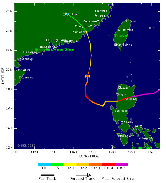
At 4 o'clock on October 21, the location of the storm center number 6 is about 19.1 degrees North latitude; 117.4 degrees Kinh Dong, on the northeastern area of the East Sea, about 600km from Hoang Sa archipelago to the East North East. The strongest wind is in the area near strong storm level 15 (that is, from 167 to 183 km per hour), level 16, level 17.
Vietnam could be assured of this storm to focus on overcoming the consequences of the flood that just happened (Photo: tropicalstormrisk)
At 4:00 on October 22, the location of the storm center will be about 20.9 degrees North latitude; 117.5 degrees east longitude, about 400km from Hong Kong (China) to the southeast of Southeast. The strongest wind in the area near the storm center is strong level 15 (that is, from 167 to 183 km per hour), level 16, level 17. From the center of the storm, the dangerous strong wind zone from level 10 or higher has a radius of about 200 km, from level 6 or higher has a radius of about 400 km.
At 4 o'clock on October 23, the location of the storm center is about 22.6 degrees North latitude; 116.8 Kinh Dong, about 290km from Hong Kong to the East. The strongest wind in the area near the storm center is strong at level 13, level 14 (ie from 134 to 166 km per hour), level 15 and level 16. The magnetic center of the storm, dangerous windy zone from level 10 or higher is sold glass about 150 km, from level 6 or more has a radius of about 350 km.
In the next 48 to 72 hours, the storm moved in the direction between Northwest and West Northwest, about 10 km per hour. By 4 o'clock on October 24, the location of the storm center was about 23.5 degrees North, 115.1 degrees east longitude, in the area of Guangdong province (China), about 170 kilometers northeast of Hong Kong. . The strongest winds in the area near the storm center are strong at level 11, level 12 (ie, from 103 to 133 km per hour), jerky level 13, level 14.
Mr. Le Thanh Hai, Deputy Director of the Central Hydrometeorological Center said: ' Up to this point, we can be assured to overcome the consequences of the flood in the Central region. Megi storms no longer pose a danger to Vietnam, only affect the sea. On the mainland area of the North, Central Highlands and Southern regions, it is likely that rain will be affected by storm surges '.
54 people died, 20 were missing
According to local statistics, as of 21:00 on October 20, 54 people died because of floods in the Central region, an increase of 8 people compared to October 19. Specifically: Nghe An: 20 people (up 4 people); Ha Tinh: 20 people (down 1 person); Quang Binh: 9 people (up 1 person), Thanh Hoa: 5 people (up 4 people).
The number of missing people is 20 people (down 1 person). In which: Ha Tinh has 1 person and 19 people missing due to passenger car being turned over. 44 people were injured (up 26 people), including Nghe An: 2 people; Ha Tinh: 26 people; Quang Binh: 16 people.
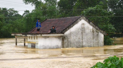
There were 54 deaths, 20 missing in the last flood. (Photo: VietNamNet)
Up to 19:00 on October 19, Ha Tinh province has moved more than 17,512 households / 68,673 people to safe places; mobilizing 300 tons of instant noodles, 70,000 liters of bottled drinking water, extracting the budget of 50 billion VND to support districts to buy food and relief supplies for people in flooded areas.
The left bank of Lam (Nghe An) section from Km78 + 400 - Km78 + 450 is eroded due to flood water which has been treated with bamboo poles and covered with earth sacks to ensure safety. The incident of Ru Ty dike (Duc Tho and Ha Tinh districts) did not cause any damage to people.
All 3 provinces of Nghe An, Ha Tinh and Quang Binh still have 319 communes submerged in water. To ensure clean water for people in flooded areas, the National Center for Rural Water Supply and Sanitation - Ministry of Agriculture and Rural Development has transported water treatment chemicals to the central provinces. As of October 20, there were 5.100kg PUR, 6,000kg Cloramin B, 300,000 Aquatab tablets, 3,000 personal hygiene bags were issued to the flooded area.
At present, National Highway 1A has completely opened traffic (after being banned in Ha Tinh due to big water). About railways: Some sections in Ha Tinh province managed by Nghe Tinh railway management company and in Quang Binh province managed by Quang Binh railway management company are still flooded and collapsed. miss.
[#RelatedNews (10) #]
 Is the magnetic North Pole shift dangerous to humanity?
 Washington legalizes the recycling of human bodies into fertilizer
 Lightning stone - the mysterious guest
 Stunned by the mysterious sunset, strange appearance