Super typhoon Haima jumped above level 17, moving rapidly into the South China Sea
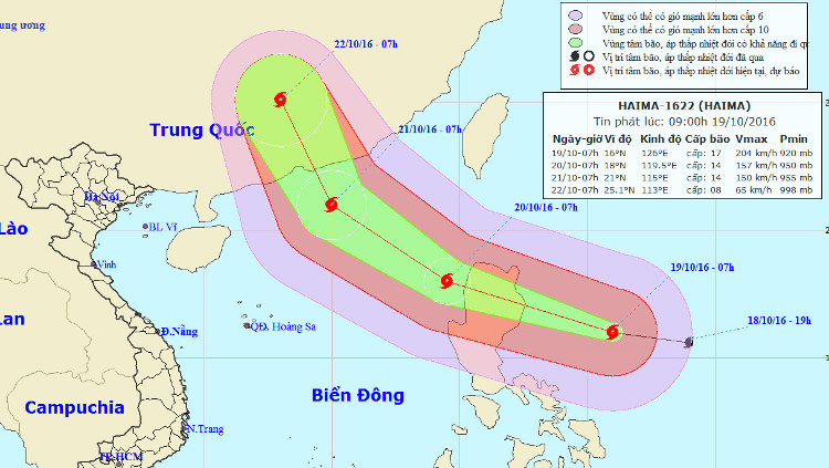
At 07:00 on October 19, the location of the center of the storm was about 16.0 degrees north latitude; 126.0 degrees Kinh Dong, about 440 km from Lu Dong Island to the East Southeast. The strongest wind in the area near the center of strong storm level 17 (200-220km / hour), jerking on level 17.
It is forecasted that in the next 24 hours , the storm will move west-northwest, about 25-30km per hour. By 07:00 on October 20, the location of the storm center is about 18.0 degrees North latitude; 119.5 degrees Kinh Dong, in the Northeast of the East Sea, about 150km from Lu Dong Island to the Northwest. The strongest wind is in the area near the center of strong storm level 14 (150-165km / hour), level 16-17.
Direction of storm Hai Ma.
Due to the impact of storms, from early October 20, the East Sea in the North East Sea has strong winds up to level 8-12, the area near the center of the storm passes through level 13-14, jerks at level 17. bouncing. Disaster risk level: level 3.
In the next 24 to 48 hours , the storm moves in the West-Northwest direction, 20-25km per hour. By 07:00 on October 21, the location of the center of the storm was about 21.0 degrees north latitude; 115.0 degrees east longitude, about 180km from Hong Kong (China) to the southeast. The strongest wind in the area near the storm center is strong at level 13-14 (135-165km / hour), level 16-17.
Due to the impact of the storm, the East Sea in the East Sea has strong winds of level 8-12, the area near the center of the storm passes through level 13-14, jolts level 17. The sea is rough. Disaster risk level: level 3.
In the next 48 to 72 hours , the storm is capable of changing the direction of travel in the North-West direction, 20-25km per hour.
- Haima storm causes level 16 wind to enter the South China Sea
- Super Typhoon Mangkhut jumped above level 17, accelerating into the South China Sea
- Super typhoon on level 17 is entering the South China Sea
- Why is the storm No. 6 constantly growing, moving unpredictably?
- Super Typhoon Mangkhut lowered 2 levels after sweeping the Philippines, moving faster into the South China Sea
- Typhoon Yutu is level 16, entering the South China Sea tonight
- Vietnam may face new super typhoons
- Nakri is probably the strongest storm since the beginning of the year in the South China Sea
- Typhoon Linfa has entered the South China Sea
- Severe typhoon level 16 is about to enter the South China Sea
- Why do a series of super storms suddenly appear around the world?
- Typhoon Sarika will land in Vietnam
 Is the magnetic North Pole shift dangerous to humanity?
 Washington legalizes the recycling of human bodies into fertilizer
 Lightning stone - the mysterious guest
 Stunned by the mysterious sunset, strange appearance