Tembin storms into Ca Mau tonight
With a wind speed of 100km / h, Typhoon Tembin will enter the mainland of the Southwestern provinces, the stormy direction will be directed to Ca Mau.
Last night, Typhoon Tembin passed Truong Sa and Huyen Tran (Khanh Hoa) with winds of 100km / h (level 11), jerked at level 14; Particularly at DK1 / 19 station, wind is stronger than two levels.
At 5 am on December 25, the storm center is about 330 km east of Con Dao (Ba Ria - Vung Tau). The strongest wind is about 135km / h (level 12), two levels of shock.
Move mainly in the West with the speed of 25km / h, the night and tonight, the storm will enter the provinces of Ba Ria - Vung Tau to Ca Mau with wind speed of 100km / h (level 10), shock level 12. Early in the morning, the storm is in the Southwest region, keeping the wind.
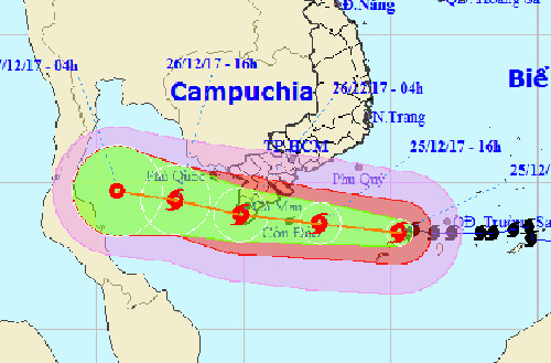
Going to Typhoon Tembin according to the forecast of the Central Hydrometeorological Forecast Center.
After entering the mainland, the storm is forecast to continue west, speed is still 20-25km / h. At 16:00 on December 26, the storm center was about 100 km west of Tho Chu (Kien Giang) with the highest wind speed of 75km / h (level 8), and level 11 shock. After that, the storm weakened into tropical depression. on the Gulf of Thailand.
In today and tomorrow, the weather on the waters of the country continues to be bad. Especially the provinces from Ba Ria - Vung Tau to Ca Mau (including Con Dao) have strong 9-11 winds, jerk to level 14. The disaster risk level in this area is level 4.
The sea from Quang Ngai to Khanh Hoa has strong winds of level 7, level 9; The waters of Ninh Thuan and Binh Thuan (including Phu Quy island) have stronger winds than one level.
The Southern Meteorological and Hydrological Station said that in the South Vietnam, the storm and the typhoon in the present day and tomorrow cause big rain to come with strong gusts and tornadoes. Particularly in Soc Trang, Hau Giang, Bac Lieu, and Ca Mau provinces, there are strong winds of level 10 (100km / h), two levels of shock. Level of disaster risk is level 4.
The provinces of Tien Giang, Ben Tre, Tra Vinh, Vinh Long, Can Tho, and Kien Giang are lighter than one level; The other land in the South and the provinces from Binh Dinh to Binh Thuan has the strongest wind level 7, level 9.
Rainfall in the Southeast provinces is forecasted to be 50-120mm (Con Dao alone 100-150mm); Southwest provinces 100-150mm.
- Tembin stormed up and landed in our country tonight
- Typhoon Tembin made landfall in South Korea causing much damage
- Why did Typhoon Tembin kill so many people in the Philippines?
- Typhoon Tembin lowered the level
- Why say Typhoon Tembin is a catastrophic storm?
- Typhoon Tembin swept over, the DK1 rig shook
- The sea was strong because of the influence of the circulation of storm Tembin
- Typhoon Tembin jumped 13, the North warmed
- Typhoon Tembin weakened into a tropical depression
- Typhoon Yutu is level 16, entering the South China Sea tonight
- The North faces dangerous weather patterns
- Storm No. 15 has not melted, near the East Sea, a new storm appears
 Is the magnetic North Pole shift dangerous to humanity?
 Washington legalizes the recycling of human bodies into fertilizer
 Lightning stone - the mysterious guest
 Stunned by the mysterious sunset, strange appearance