Tropical depression intensified into Typhoon Haikui
In the evening, the tropical depression intensified into a storm with the international name Haikui, this is the number 13 storm in the East Sea.
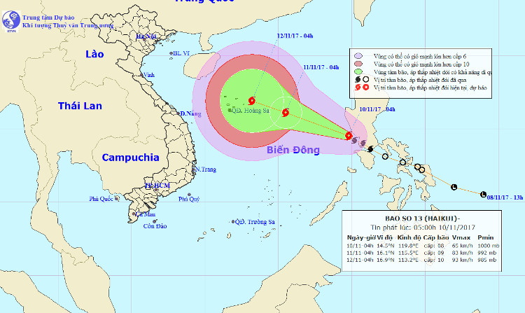
Early this morning ( November 10) Typhoon Haikui crossed the southern Lu-Dong area of the Philippines into the East Sea, the storm No. 13.
At 4:00 am on November 10 , the position of the center of the storm is about 14.5 degrees north latitude; 119.8 degrees Kinh Dong is about 930km to the South East of the Paracel Islands. The strongest wind is in the area near the center of strong storm level 8 (60-75km / hour), level 10 shock.
Location and direction of Typhoon Haikui.
It is forecasted that in the next 24 hours, the storm will move west and northwest, about 20km per hour, there will be more powerful possibilities. At 04:00 on 11/11, the location of the center of the storm is about 16.1 degrees North latitude; 115.5 degrees east longitude, about 430 km from Hoang Sa archipelago to the East of Southeast. The strongest wind in the area near the storm center is strong at level 9 (75-90km / hour), level 12 jerks.
Due to the influence of typhoons, the East Sea in the North and the East Sea has heavy rain and thunderstorms, strong winds gradually rise to level 6-7, the area near the center of the storm passes through 8-9 level, level 11 jerks -twelfth. The sea is very strong. Dangerous zone in the next 24 hours (strong wind level 6 or higher) from latitude 12.0 to 17.0 degrees North latitude; east of meridian 113.5 degrees east longitude.
Disaster risk level: level 3.
It is forecasted that in the next 24 to 48 hours , the storm will move in the West-Northwest direction, every hour will be about 10-15km and further strengthened. At 04:00 on November 12, the location of the storm center is about 16.9 degrees North latitude; 113.2 degrees east longitude, on the eastern area of the northeastern Hoang Sa archipelago. The strongest wind is in the area near the center of strong storm level 9-10 (75-100km / hour), level 13 shock.
It is forecasted that in the next 48 to 72 hours , the storm will move west and northwest, about 5-10km per hour.
- Tropical depression intensified into a storm - typhoon Kai-Tak
- Storm No. 13 weakens into a tropical depression
- Tropical depression intensified into storm No. 14, affecting South Central
- Tropical depression intensified into storm No. 2
- Tropical depression strengthened to No. 6, Nakri
- Matmo storm weakened into a tropical depression
- Tropical depression strengthened into a typhoon No. 5, heading to Binh Dinh - Phu Yen
- Typhoon Sarika weakens into a tropical depression
- Tropical depression intensified into storm No. 3 - WIPHA storm
- Tropical depression intensified into storm No. 3
- Tropical depression on the South China Sea strengthened into a storm - storm Bebinca
- Tropical depressions move quickly at sea, with the possibility of strong storms
 Is the magnetic North Pole shift dangerous to humanity?
 Washington legalizes the recycling of human bodies into fertilizer
 Lightning stone - the mysterious guest
 Stunned by the mysterious sunset, strange appearance