Tropical depressions move quickly at sea, with the possibility of strong storms
According to the National Center for Hydrometeorological Forecasting, the tropical depression on the sea moves quickly in the Northwestern direction, every hour it travels about 15km and is likely to become a typhoon.
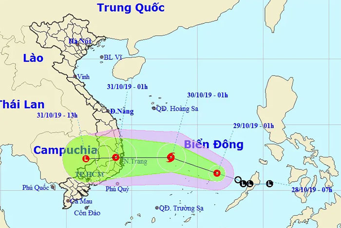
At 1h on October 29 , the location of the tropical depression was about 11.3 degrees North latitude; 116.5 degrees Kinh Dong, about 250km to the East from Song Tu Tay Island (Spratly Islands).
The strongest wind near the center of tropical depression is at level 6-7 (40-60km / h), level 9. The wind radius of level 6, level 8 or higher is about 70km from the center of tropical low pressure.
Location and direction of movement of tropical depressions.(Photo: NCHMF).
It is forecasted that in the next 24 hours , tropical depressions will move quickly in the Northwestern direction, traveling about 15km every hour and likely to become typhoons. Until 1h on October 30, the center of the storm was about 12.5 degrees Vi Bac; 113.0 degrees Kinh Dong, about 410 km to the east from the provinces of Phu Yen - Khanh Hoa. The strongest wind near the center of strong storms level 8 (60-75km / h), level 10.
Dangerous areas in the East Sea in the next 24 hours (strong winds of grade 6, level 8 or higher) : North of the North latitude 10.0 degrees North; east of Meridian 111.0 degrees Longitude.
In the next 24 to 48 hours , the typhoon moved rapidly to the West, every hour went 20-25km, went to the mainland of provinces from Binh Dinh to Ninh Thuan with strong winds of 7-8, level 10 after that. weakening into tropical low pressure.
By 1:00 on October 31 , the location of the tropical depression was about 12.5 degrees Vi Bac; 108.8 degrees Kinh Dong, on the mainland of South Central provinces. The strongest wind near the center of strong tropical depression is level 6-7 (40-60km / h), level 9.
Over the next 48 to 60 hours, the tropical depression moved westward, traveling 15-20km every hour and weakening into a low pressure area.
Strong winds in the Sea: Due to the effect of the following tropical depression, the strong winds in the North and the South China Sea and the northern sea area of the Spratly Islands have a strong wind level of 6-7, and then increase. level 8, level 10 shock; The sea is very strong.
From tomorrow (October 30) , in the offshore areas of provinces from Quang Ngai to Ninh Thuan, the wind gradually rises to level 7, the area near the center of the storm goes to level 8, level 10; the sea is very strong; In the Tonkin Gulf and the sea area from Quang Tri to Quang Nam, the strong northeast wind is grade 6-7 and level 8; rough sea.
Very heavy rain in Central and Central Highlands: From October 30-31, provinces / cities from Thua Thien Hue to Ninh Thuan and Central Highlands regions have very heavy rain (total rainfall 300-400mm / batch, separately Binh Dinh, Phu Yen and Khanh Hoa 400-600mm / batch). From October 31 to November 2 in provinces from Thanh Hoa to Thua Thien Hue with heavy to very heavy rain (Total popular rainfall is 200-300mm / batch, particularly Nghe An, Ha Tinh, Quang Binh 300-500mm / installments).
Warning: From November 4 to 5, heavy rain is likely to reappear in Central and South Central provinces.
From October 30, on rivers from Ha Tinh to Ninh Thuan and the Central Highlands region, there is a possibility of a large flood with the peak water level on the rivers at alarming levels (B) 2 to B rivers and streams small and upstream of rivers up to the level 3, the risk of flash floods, landslides and floods in the above areas.
- Tropical depressions are likely to become strong storms towards the North
- Occurrence of tropical depression near the South China Sea, the possibility of strong storms
- Tropical depressions enter the South China Sea, potentially strong into storms
- Tropical depressions may intensify into storms when approaching the Spratlys
- Typhoon has just melted, tropical depressions are about to enter the South China Sea
- Tropical depressions melted, the flood in the Central region increased quickly
- News of nearshore tropical depressions and tropical depressions near the East Sea
- Correct understanding of storms and tropical depressions
- Tropical depressions are likely to become strong storms, Bac Bo heavy rain
- Latest news about two tropical depressions consecutively in the South China Sea
- Latest news about tropical depression
- Occurrence of tropical depressions in the East Sea is likely to increase to a storm
 Is the magnetic North Pole shift dangerous to humanity?
 Washington legalizes the recycling of human bodies into fertilizer
 Lightning stone - the mysterious guest
 Stunned by the mysterious sunset, strange appearance