Typhoon Krosa threatens the Central
At 13 o'clock on October 31, the location of the center of the storm was about 18.0 degrees north latitude; 123.1 degrees east longitude, on the northeastern coast of Luong Dong Island (Philippines). The strongest winds in the area near the storm center are strong at level 11, level 12 (ie 103 to 133 km per hour), level 14 and level 15 jerks.
It is forecasted that in the next 24 hours, the storm will move in the direction of West and West Northwest, about 20-25 km per hour. By 13:00 on November 1, the location of the center of the storm was about 18.8 degrees Vi Bac; 117.8 Kinh Dong, about 630 km from Hoang Sa archipelago to the East North East. The strongest winds in the area near the storm center are strong at level 11, level 12 (ie 103 to 133 km per hour), level 14 and level 15 jerks.
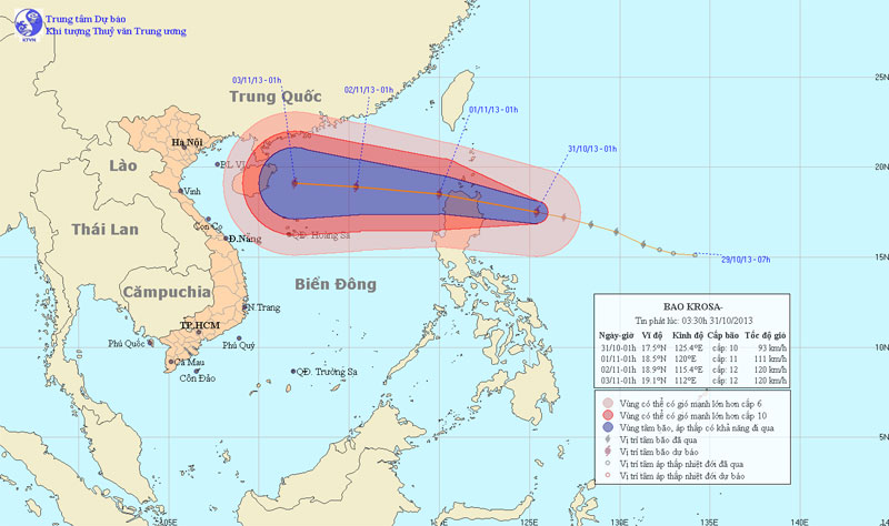
Photo of the path and location of hurricane Krosa
In the next 24 to 48 hours, the storm continues to move in the direction of West and West Northwest, about 15 - 20km per hour. By 13:00 on November 2, the location of the storm center was about 19.1 degrees North latitude; 114.0 degrees Kinh Dong, about 320km from Hoang Sa archipelago to the Northeast. The strongest winds in the area near the storm center are strong at level 11, level 12 (ie 103 to 133 km per hour), level 14 and level 15 jerks.
In the next 48 to 72 hours, the storm has the ability to change the direction of travel in the direction of West and West Southwest, about 10 to 15 km per hour.
Due to the impact of typhoon circulation, from tonight (October 31), the East Sea in the East Sea has strong winds up to level 6, level 7, then increases to level 9, level 10, and the area near the storm center. strong level 11, level 12, shock level 14, level 15. The sea is fierce.
- Typhoon Krosa can cause heavy rain in the Central region
- Typhoon Krosa is strong up to level 15, going straight to the Central
- Typhoon Krosa is stronger and accelerates into the South China Sea
- Storm No. 12 constantly changes direction
- A storm near the East Sea appears
- Hurricane Krosa jerked level 13 into the South China Sea
- Actively respond to hurricane Krosa
- Typhoon Krosa landed in China, one million people were evacuated
- Podul storm threatened the central provinces
- Storm No. 12 weakens into a tropical depression
- Tom Tinh storms tomorrow night into Central Vietnam
- The Storm of the Mountain Is Focusing on Central
 Is the magnetic North Pole shift dangerous to humanity?
 Washington legalizes the recycling of human bodies into fertilizer
 Lightning stone - the mysterious guest
 Stunned by the mysterious sunset, strange appearance