Typhoon landed from Quang Ninh to Nam Dinh
At 4 am this morning, the storm center is only 170km from the coast of Quang Ninh - Nam Dinh provinces, strong at level 12. With the speed of 15km per hour, only 16-17h this afternoon is focused on the mainland. On the way, the storm caused much damage.
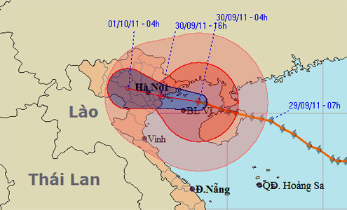
Predict the path and impact area of the storm. (Photo: NCHMF)
The central hydro-meteorological center said that the location of landfall was identified as provinces from Quang Ninh to Nam Dinh, strong at level 10-11. Inland, the storm weakened rapidly, until now at 16pm, the storm was centered in the southern part of the Northern Delta, and level 8-9.
Before going to shore, Typhoon Nesat caused strong winds of 9-10 level at Cua Ong (Quang Ninh), Co To, Bach Long Vi (Hai Phong). The rain accompanied by the wind caused a lot of trees to fall, some houses were roofed.
In Hanoi, due to the pre-storm circulation combined with the influence of cold air, the area had rain all night, but not large. Earlier today, when the storm approached the shore, the rain began to intensify. It is forecasted that in the whole period of about 3 days, Hanoi's rainfall will reach about 200 mm.
Formed on September 24 off the east coast of the Philippines, three days after the Nesat storm swept across the country, 18 people were killed, more than 100,000 people were evacuated. On September 29, the typhoon struck Hainan Island, Macau and Hong Kong, causing many trees to turn on, the traffic stopped.
At the east of the Philippines, there is an international storm called Nalgae, which is expected to go west, sweeping through the Philippine island of Luzon, into the South China Sea and heading to Central Vietnam.
- This afternoon, Typhoon Nesat landed in Quang Ninh - Nam Dinh
- Typhoons in Quang Ninh cause flooding in Mong Cai, Hanoi and heavy rains threaten to flood many streets
- Storm No. 5 is likely to target Quang Ninh - Nam Dinh
- Entering the capital of Hanoi, the storm weakened into a tropical depression
- Typhoon landfall in Quang Ninh - Nam Dinh, heavy rain up to 400mm, 4.0-4.5m rise
- Quang Ninh suddenly interested in Typhoon Haiyan
- Tonight the storm landed Hai Phong, Thai Binh and Quang Ninh
- Storm No. 4 jerk level 10, heading to Quang Ninh - Nam Dinh
- Typhoon hit Quang Ninh
- Video: Haiyan storm landed, causing flooding in China
- Typhoon Mirinae in Nam Dinh - Ninh Binh
- Storm No. 7 can enter Quang Ninh - Hai Phong
 Is the magnetic North Pole shift dangerous to humanity?
 Washington legalizes the recycling of human bodies into fertilizer
 Lightning stone - the mysterious guest
 Stunned by the mysterious sunset, strange appearance