Vietnam has the first ENVISAT satellite image receiving station in Asia
Vietnam satellite image receiving station officially operated in the morning of July 9, 2009. Vietnam is the first country in Asia to have an ENVISAT satellite image receiving station.
Satellite photo receiving station is the most important item of the Construction Project of Natural Resources and Environment Monitoring System in Vietnam (ENRMS).
Satellite photo receiving station is the 5th collection station in ASEAN and is the modern collection station, selected to install technical equipment using the latest technology of EADS - French Defense and Aerospace Group.
The receiver has a higher automatic feature than other stations in the area with the main function of capturing, processing, cataloging and storing data transmitted from the satellites Spot 2, 4 and Spot 5. 2.5m resolution; ENVISAT Asar (radar image); Envisat Meris 15 universal channels.
Images obtained from Vietnam satellite image collection station
Vietnam satellite image receiving station is the first receiving station in Asia to acquire ENVISAT satellite images. Currently, ENVISAT satellite images are only obtained in Europe.
Photographic stations with open architecture, in the future can upgrade new photo receivers on demand . The above types of satellite images meet the current tasks, including Spot and Asar satellite images that directly serve land inventory, monitoring and forest inventory projects, and update the land base National management, establishment and adjustment of sea and island maps, monitoring of environmental pollution, floods .
Meris image mainly serves the study of marine physical environment such as salinity, density of algal pigment, sediment transport . for offshore fishing, fisheries management and coastal management. edge.
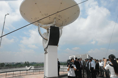
Deputy Prime Minister Hoang Trung Hai attended the inauguration ceremony of Vietnam Satellite Photo Station on the morning of July 7, 2007.
The construction of satellite image receiving stations allows for the proactive provision of remote sensing image materials for application centers . In the initial phase of the satellite image receiving station operation, the shared remote sensing database will store the original images collected at the receiving station.
In the coming time, the Ministry of Science and Technology will assume the prime responsibility for developing a legal framework and organizational solutions to exploit the system of remote sensing databases used as a legal basis for operating the system.
In the next few years, the national remote sensing database will be completely built, linked to specialized remote sensing database in a unified system, serving for sharing, searching and searching. search, provide remote sensing data and value-added products on remote sensing images . to serve the monitoring of natural resources and the environment.

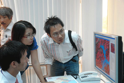
Latest images obtained from satellites.
The image data collected will serve effectively for the monitoring of natural resources and environment in Vietnam.
Talking with VietnamNet Newspaper correspondent in the inauguration of Vietnam Satellite Photo Collection Station, in the morning of July 9, 2009, Mr. Nguyen Van Lang - Deputy Minister of Science and Technology said: ' Technology of satellite image collection plays Important role in providing data and image data for natural resource and environmental monitoring. This is also an important channel for us to re-examine the accuracy of reports on issues such as controlling specific information on forest cover, flood development, forest fire . from then the agencies managing the industry have plans and specific solutions .
- Vietnam will build satellite image receiving station
- In early 2006, building satellite image receiving station
- Vietnam satellite image receiving station is ready
- Capture the world's largest satellite image missing
- The world's largest earth observation satellite is missing
- Satellite Envisat officially retired
- Vietnam is about to launch VINASAT satellite
- Spot the enchanting Earth from space satellites
- Risk of Gravity disaster in space
- Publication of the ghost image of the International Space Station
- The 7 largest objects people ever launched into space
- Can the German satellite fall to Vietnam?
 'Barefoot engineer' invents a pipeless pump
 Process of handling dead pigs due to disease
 Radiometer
 Warp Engine: Technology brings us closer to the speed of light