Why is the storm No. 6 constantly growing, moving unpredictably?
Meteorological expert said storm No. 6 is difficult to predict because of the interaction of 3 morphology on the inter-planetary convergence band There are many different scenarios for this storm.
After more than 2 days of strengthening from the tropical depression in the South China Sea, typhoon No. 6 (Nakri) is forecast to change direction, approaching land with strong winds of level 10-11, level 14 and can reach strong intensity. at level 12, level 15.
The National Center of Hydrometeorological Forecasting said that storm No. 6 could reach the mainland of Binh Dinh - Ninh Thuan provinces on November 10 with the wind intensity weaker than the previous one.
Nguyen Van Huong, Head of Climate Forecasting (National Center for Hydrometeorological Forecasting), said this forecast could be changed because the typhoon No. 6 is affected by many different forms that make the trend to move. unpredictable transfer.
Interaction of 4 storms
According to Huong, the intertropical tropical convergence band located on the tropical cyclone is active with 4 storms and tropical depressions, including: Super typhoon Halong in the Northwest Pacific, typhoon No. 6 - Nakri in the East Sea, tropical depressions in the Bay of Bengal and Hanna in the Indian Ocean.
"This is a special case when 4 tropical cyclones appear at the same time on the same ocean band from the Indian Ocean to the Pacific Northwest," Huong said.
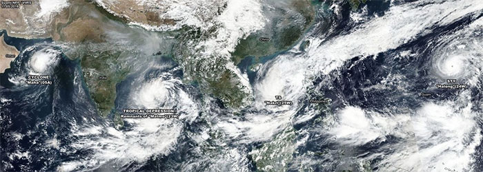
The interaction of super typhoon and tropical tropical patterns on the East Sea makes the path of typhoon No. 6 unpredictable.(Photo: NCHMF).
Accordingly, Halong super typhoon is expected to dominate the activities of many other forms due to unprecedented intensity, which is stronger than Haiyan super typhoon in 2013.
The interaction of this super typhoon will make storm No. 6 unpredictable. If Halong goes north, the tropical high pressure pushes down, causing storm No. 6 to move west. When combined with cold air movement and impact, typhoon No. 6 heads to the mainland with increasing intensity.
Meanwhile, Mai Van Khiem, director of the National Center for Hydrometeorological Forecasting, said that the No. 6 storm was continuously increasing due to moving on a warm sea. The dynamic conditions right at the active storm zone are also favorable for the storm to accumulate energy and strengthen.
In addition, cold air will begin to affect northern mountainous provinces tomorrow (November 7). The combination of continental cold pressures to the south and cold northern air create a strong northeast wind on the northern edge of the storm, causing storm number 6 to accelerate rapidly.
However, due to many other central areas impacted, the scenario of movement and intensity of storm No. 6 will be constantly changing and unpredictable.
May weaken before entering land
According to the Chief of Climate Forecasting, models in the world of the US, Japan, Hong Kong, China and Taiwan currently do not have a stable forecast on the movement and landing scenario of Hurricane Nakri when entering the land. instant. Most are temporary forecasts.
Specifically, the Severe Weather Europe (Severe Weather Europe, the famous forecast center in the world) made the observation that when approaching the land, typhoon No. 6 is likely to deflect. southward and weakening before landing.
Meanwhile, according to the Hong Kong Meteorological Forecast, typhoon No. 6 reached 120 km / h (grade 12) on November 9. Shortly thereafter, the storm dropped to level 11 when it entered the waters of Quang Ngai - Ninh Thuan provinces on November 10.
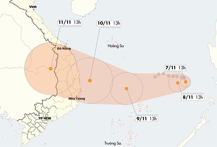
The National Center for Hydrometeorology forecast that storms could reach provinces
Quang Ngai - Khanh Hoa on November 10.(Graphic: Nhân Lê)
When it came to the mainland, the typhoon immediately weakened into a tropical depression, then a low pressure area moved to the Central Highlands. This prediction is relatively consistent with the findings of the National Center for Hydrometeorological Forecasting.
"If typhoon No. 6 follows this scenario, its area of influence will extend a spectrum from Da Nang to Ba Ria - Vung Tau," Mr. Huong said.
The expert also said that on November 8, when the storm tends to turn back and move toward the mainland, the forecast of the intensity and direction of the storm will be clearer.
- Nakri is probably the strongest storm since the beginning of the year in the South China Sea
- Tropical depression strengthened to No. 6, Nakri
- Storm No. 4: Constantly calling for shelter boats
- This morning, the storm started to cause rain in the Central region
- Hurricane No. 3, level 14, is approaching Quang Ninh - Thanh Hoa
- Storm No. 6 is approaching the Vietnam-China border, the North is about to rain very hard
- Vietnam may be affected only by storm surges
- Storm No. 7 constantly changed direction, the sea was very strong
- This evening, storm No. 5 landed on land from Quang Ngai to Khanh Hoa
- The storm with extraordinary speed is heading into the South China Sea
- Things to remember when going out on a rainy day
- Storm No. 12 constantly changes direction
- Storm No. 3 will cause rain in the North
- Podul storm landed in Quang Binh
 Is the magnetic North Pole shift dangerous to humanity?
 Washington legalizes the recycling of human bodies into fertilizer
 Lightning stone - the mysterious guest
 Stunned by the mysterious sunset, strange appearance