6 most terrifying landmarks in the world
In the world there are places known as nightmares, like hell in the world. When arriving here, sometimes there is no need for big risks such as extreme weather, wild animals, but only a small event can cause you to be injured or lose your life.
Gate to hell, Turkmenistan
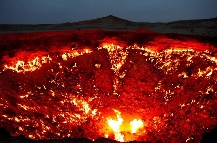
Derweze is a small village in northern Turkmenistan. With a location in the middle of the desert and a population of only 350, this is not an ideal destination for tourists. Moreover, it was close to the location of the Gate to hell - a 70-meter-wide hole that had been burning for more than 40 years. In 1971, a group of geologists unknowingly drilled through the surface of an underground cave, resulting in the collapse of the entire area and the upper platform. Fearing that this would release dangerous gases, they set fire to destroy these gases. That worked, the flames caught fire, and never stopped burning ever since. The crater is located on an underground natural gas tank, which keeps the fire burning for almost half a century.
Afar lowlands, Africa
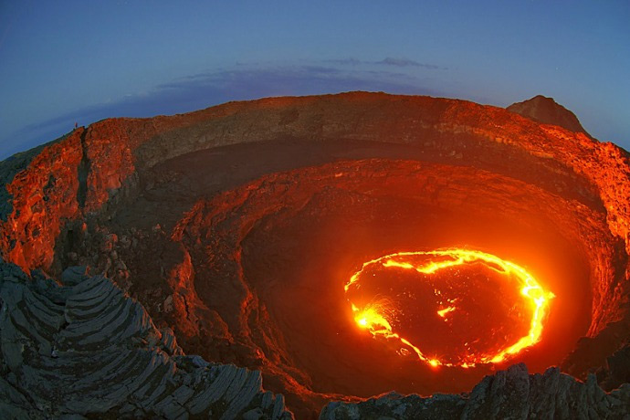
It's hard to imagine when you go to a place where the ground is constantly moving, the pits appear unexpectedly, and the soil beneath your feet can disappear completely. That is the Afar lowland in Eastern Africa, one of only two points in the world can see the rising mountains under the sea. This is where the two geological tectonic plates meet and are also the most geologically active areas on earth.
In just two months from September to November 2005, the land suffered 165 earthquakes of over 3.9 degrees, along with smaller earthquakes. The area is also home to one of the world's largest lava tanks (Erta Ale) and scientists believe that the Horn of Africa region will soon be separated from the continent in this area.
Namaskaro, Iceland
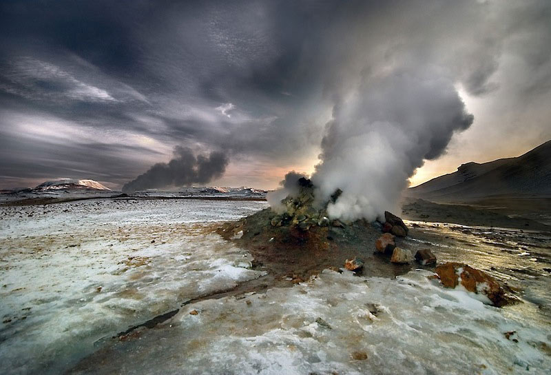
Namaskara is an area in Iceland, located at the foot of Mount Namafjall, one of the active volcanoes in this area. In fact, the entire region is a hot spot of geothermal activities with the most gloomy and chaotic scenes in the world. The ground is covered by the solfaratas - the mud lake is from 1 to more than 10 meters wide. Among these mud pools are steam vents and a range of other volcanic gases, forming a mist that covers the entire area. The hot ground evaporated with complete absence of any plant species that gave off a terrifying feeling to this land.
Tsingy de Bemaraha National Park, Madagascar
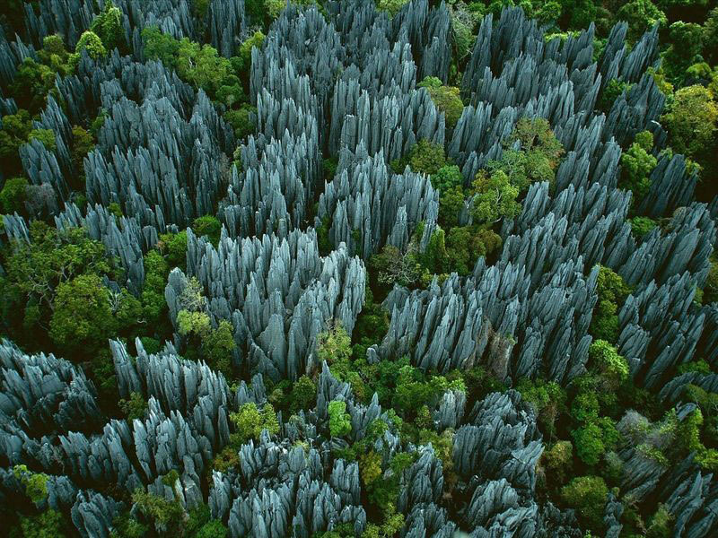
This park can be one of the strangest places you've ever seen. The entire area is covered with sharp rocks , some 120 meters high. These rocks are formed when seawater is corroded and becomes razor-sharp, and there are hundreds of species of plants and animals that cannot be found anywhere else in the world. This is also one of the least studied locations. The terrain here is too dangerous, only a few scientists who go deep into this area find out and the number of returnees can only count on the fingertips.
Blue lake, Russia
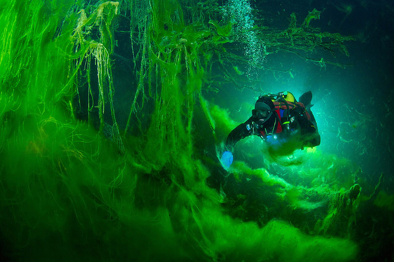
This lake becomes special because it is difficult to see the water flows in this area. Water travels through underground caves at the bottom of the lake and although scientists have estimated the depth of the lake to be 250 meters, they still cannot find groundwater flows into the lake. It has the deepest cave system ever known in the world, so it is difficult to discover the bottom of the lake, even the idea that the lake is completely bottomless .
In addition, due to the high sulfur content, the lake water always has a distinctive bright green color, making it more and more attractive, and anyone who has tried to dive doesn't want to stay long.
Truk Bay, Micronesia island nation
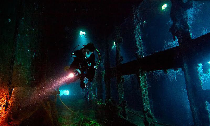
Located off Micronesia, this tropical water is one of the world's largest rafting vessels . At World War II, the Japanese chose this area to establish one of the bases to attack the Allies in the South Pacific. It soon became the largest base in the region, until February 1944 when US forces attacked and sank 60 ships and 275 aircraft. Today, the waters hide hundreds of wrecks and planes below the water. The bay is surrounded by a coral reef, whereby it is protected from outside ocean influences. As a result, most wrecks remain intact.
There are still unexploded bombs , necessities and even the remains of human remains under the cavity and on the deck.
- These 9 famous landmarks are about to disappear forever, all because ...
- Beautiful set of photos about wild ruins throughout the planet
- Little secret at world famous landmarks
- 10 first landmarks in human history
- This is what you see from the top of the highest places in the world
- The most mysterious place on the planet
- Collection of surreal 'surreal' landmarks that exist on Earth
- The most feared landmarks in Asia
- 3 beautiful places are told in swordplay Kim Dung
- Appearance of American cities when sea level rises
- The beauty of 'hard to resist' of 20 places in the world when spring comes
- The most terrifying tourist destinations on the planet
 History of the iron
 The sequence of numbers 142857 of the Egyptian pyramids is known as the strangest number in the world - Why?
 'Fine laughs' - Scary and painful torture in ancient times
 Himba tribe has topless women in Africa