Tectonic plates under the Indian Ocean are broken in two
India - Australia - Capricorn tectonic plates are splitting at a rate of about 1.7 mm a year.
In a million years, the distance between the two halves of this tectonic plate will be 1.7 km further than it is today, according to Aurélie Coudurier-Curveur, a marine geoscience researcher at the Paris Earth Physics Institute. . Coudurier-Curveur and colleagues published their findings today 11 May in the journal Geophysical Research Letters.

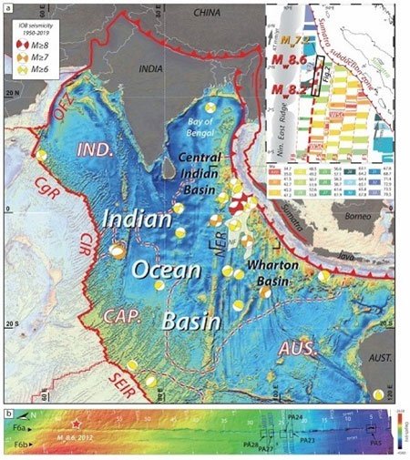
The Wharton basin was the site of two 2012 earthquakes. (Image: Live Science)
Compared to this tectonic plate, the Bien Chat fault in the Middle East moves twice as fast, about 0.4cm a year, while the San Andreas fault in California moves 10 times faster, at 1.8cm. a year. The Indian-Australian-Capricorn tecton separates so slowly and so deep in the water that researchers almost ignore the tectonic plate boundary without proof that two strong earthquakes originated from a strange spot in India. Ocean.
On April 11, 2012, a magnitude 8.6 and 8.2 magnitude earthquake struck the Pacific Ocean, near Indonesia. The two earthquakes did not occur along the sinking zone, where one tectonic plate slipped below the other. Instead, they originate in the middle of tectonic plates. These earthquakes revealed some subterranean deformation in an area called the Wharton basin.

The splitting process of the Indian - Australia - Capricorn tectonics occurs underwater at a very slow speed, which is difficult to detect. (Photo: EOS).
The team looked at a particular fault area in the Wharton basin , where the earthquake originated. Two datasets in this area, collected by scientists onboard in 2015 and 2016, show the topography of the fault area. By recording the time it takes for the sound waves to propagate from the seabed and bedrock, the research vessel can map the basin topography.
When Coudurier-Curveur and colleagues looked at two sets of data, they found that the evidence for the extension was the subsidence that formed in the transverse fracture fracture area. The most famous horizontal fracture break is probably San Andreas fault. This type of fault causes earthquakes when two pieces of the Earth's crust slide across each other horizontally. The team found 62 basin basins along the mapped fault zone, spanning nearly 350 km. Some basins are gigantic in size, 8km long and 3km wide.
In addition, the subsidence was deeper in the south (120 m) and shallower than in the north (5 m). According to Coudurier-Curveur, this means that horizontal fracture faults are concentrated on the southern boundary, at least for the time being. The basins began to form about 2.3 million years ago, after a fault formed along the epicenter in 2012. Because different parts of the India-Australia-Capricorn plate moved at different speeds, the fracture zone This fracture is becoming a new boundary for tectonic plates to split in half.
- Found tectonic plate
- The source of unrest among tectonic plates
- Ruby and jade illuminate the history of the Earth
- The reason for Mexico's strong earthquake
- Rosat 'satellite may fall to the Indian Ocean'
- Not only because of meteors, the main reason for the extinction of dinosaurs was unexpected
- Detected 'strange' package in Chinese disk
- The mystery of the rise of the Himalayas
- Why do the ancient ancestors of human beings walk on two legs?
- Determine the cause of earthquakes in Sichuan
- Detecting strange tectonic plates at a depth of 660km in the South Pacific
- Water in the Indian Ocean flows into the Atlantic Ocean
 'Fine laughs' - Scary and painful torture in ancient times
 The sequence of numbers 142857 of the Egyptian pyramids is known as the strangest number in the world - Why?
 History of the iron
 What is alum?