Decode mystery aircraft under the lake
Mysterious about an intact passenger plane located at the bottom of Lake Harriet in Minneapolis, the US finally got the answer.
The image on Google Earth about the sunken airplane has caused authorities to open an investigation.
Officials overseeing the parks in Minneapolis were worried when they looked at photos of a submerged twin-engine airplane, they had no information about a plane that crashed. An investigation was started when a series of conspiracy theories began to emerge.
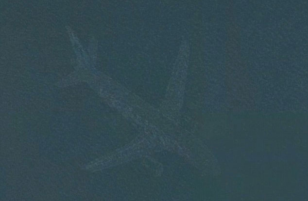
Photo of a plane at the bottom of the lake.(Photo Google Map).
However, it turned out that the picture was only a minor issue in Google Earth's imaging function and in fact there were no passenger planes sunk in the water.
Google engineers reviewed the problem and explained what happened.
Susan Cadrecha, a Google Map spokesman, told The Minneapolis Star-Tribune: "In short: every satellite image you see on the map is actually a combination of several photos. Moving objects. As fast as an airplane usually only appears in one of the photos we give to a certain area. When that happens, sometimes a trace of a fast moving object can be seen. "
A similar image is also found at nearby Lake Nokomis, although both lakes are located away from the Minneapolis-St international airport. Paul is over 10km away. Each year, more than 400,000 planes take off and land at the airport.
Lake Nokomis and Harriet are both on the flight routes of many aircraft, so it is likely that photos of Google Earth can capture images of an airplane flying through these two lakes.
- Discover the secrets of the world's most salty lake
- 'Lake of the devil': Detects tremors at a depth of 4000m
- The ancient 'city' mystery at the bottom of the lake no one knows for thousands of years
- Mysterious about Lake Baikal - The largest lake in the world
- Hot: The mystery of Loch Ness lake monster has a solution
- Decipher the mystery of the lakes disappearing in a few hours in Greenland
- Decode the plane 'Doomsday' of America
- Discover the mystery of the
- Be ecstatic with the most beautiful lakes in the world
- 10 lakes are beautiful but can kill people
- Monster Lake Nix
- The trout of thousands of salmon is flown into the lake by the aircraft
 History of the iron
 The sequence of numbers 142857 of the Egyptian pyramids is known as the strangest number in the world - Why?
 'Fine laughs' - Scary and painful torture in ancient times
 Himba tribe has topless women in Africa