New Earth Map
The US Aeronautics and Space Agency (NASA) said on October 17 that it has published the most complete digital Earth topographic map, created in collaboration with Japanese research experts. and use satellite data.

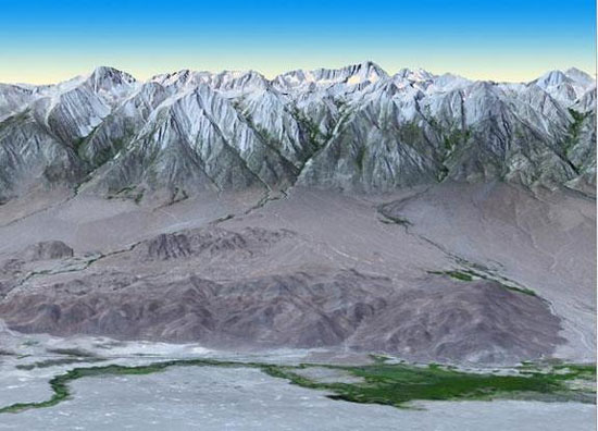
Photo of Mount Whitney in California with ASTER device - (Photo: NASA)
The map above, called the global digital elevation model, is made up of Japanese images taken with ASTER (space-reflecting and radiant radiation measuring device) on Terra's space ship. NASA.
The ASTER device , launched with Terra in 1999, received images from visible to infrared heat wavelengths.
The first version of this map was announced in June 2009 by NASA and the Ministry of Economy, Trade and Industry.
The new ASTER map, which is provided free online, covers 99% of the mainland area and extends from 83 degrees north to 83 degrees south latitude.
'This updated version of the global digital elevation model provides users with global topographic data with the highest resolution , ' said Mike Abrams of NASA's Jet Propulsion Laboratory. California (USA) said.
'These data can be used for a range of applications, from highway planning to protecting land areas of cultural and environmental importance, to finding natural resources. ' he added.
- 10 interesting facts about Earth you may not know
- The Earth may have swallowed its planet
- The 8 biggest mysteries about Earth
- History and meaning of Earth Day
- Scientists think that these are the eight most likely cases of life eradication
- Video: Discover everything about Earth
- Unbelievable facts about the Earth
- Earth Overshoot Day - the time when humanity abused resources exceeded Earth's recovery threshold
- Revealing the mysteries of the Earth makes everyone 'startled'
- Video: Earth image at night
- Impressive image of Earth Day
- Video: Interesting things about the Earth
 Van Allen's belt and evidence that the Apollo 11 mission to the Moon was myth
 The levels of civilization in the universe (Kardashev scale)
 Today Mars, the sun and the Earth are aligned
 The Amazon owner announced a secret plan to build a space base for thousands of people