Satellites help predict malaria early
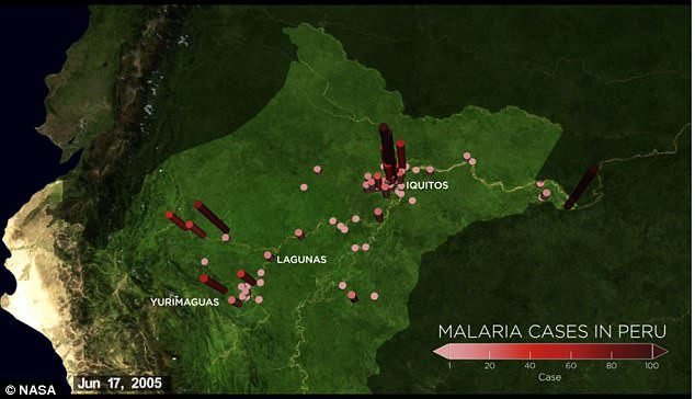
NASA has invented a predictive system where outbreaks of malaria outbreaks, based on satellites measure moisture in the air and soil. This system was first used in Peru.
Malaria is one of the biggest health threats in the tropics like Amazon and it is difficult to predict its spread. Almost everyone knows that mosquitoes often like places with warm air and on the surface of reservoirs, but how can you expand your awareness to predict a wide range of topics? prevention of this disease?
Pre-emptive malaria through satellite systems in Peru.
Researchers are using data from NASA satellites (like the Landsat series) to predict malaria outbreaks by identifying areas where moisture is generated by the soil - the source for mosquitoes to transmit. sick.Flooding and deforestation are the main causes of water tanks - habitats of mosquitoes.
Along with sophisticated models comparing the level of infection based on occupation and work environment such as woodworkers and miners working in humid conditions. A unified system will be able to predict malaria outbreaks 3 months ago, this system is used for individual households.
The model based on satellite operation will be screened before being put into use and it will be effective within a few years. If so, in addition to preventing outbreaks of disease through timely responses, the system also offers effective ways to combat disease for users.
Even at this time, countries like Peru have begun to be tested, then distribute bed nets, mosquito repellents and other tools because they have seen where there is a possibility of an outbreak. This new model can focus on supporting specific neighborhoods, saving resources because it takes applications in different places.
- Predicting malaria epidemic thanks to sea temperature
- How to diagnose, treat and prevent malaria
- New NASA satellites can predict droughts and floods
- The first vaccine against malaria loses its effectiveness after 4 years of injection
- A malaria vaccine has been developed
- A breakthrough in preparing malaria vaccines
- Demeter: Early warning system for malaria epidemic
- New way to kill malaria parasites
- The trial of malaria vaccine achieved positive results
- Conduct a trial on human malaria vaccine
- Malaria changes the smell of patients, makes them more
- Tools for detecting fake malaria
 Van Allen's belt and evidence that the Apollo 11 mission to the Moon was myth
 The levels of civilization in the universe (Kardashev scale)
 Today Mars, the sun and the Earth are aligned
 The Amazon owner announced a secret plan to build a space base for thousands of people