Things you don't know about meridians and latitudes
Here are the most basic and understandable concepts about meridians and latitudes, as well as how to determine the latitude and longitude on the map, invite you to see.
What is meridian?

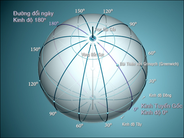
Root meridian, Meridian 180 ° (modified line) and location of Greenwich Observatory.
The meridian is a semi-circle on the surface of the Earth, connecting the two Polars, about 20,000 km long, pointing north-south and cutting perpendicular to the equator. The plane of the meridian 0 ° (runs through the astronomical observatory in Greenwich in London) and the meridian 180 °, divides the Earth into two hemispheres - the Eastern Hemisphere and the Western Hemisphere.
The meridians connect the magnetic poles are magnetic meridians, the meridian connecting the Polars is called the meridian, while the meridian lines on the map - are the meridians.
This meridian is also called the meridian , to distinguish it from the meridian meridian, which is the intersection between the surface of the Earth and the plane passing through the straight line connecting the polar regions from North and South.
What is latitude?
On Earth or planets or spherical bodies, the latitude is an imaginary circle that connects all points of the same latitude. On Earth, this circle has a direction from east to west. Location on the latitude is determined by longitude. A parallel is always perpendicular to a meridian at the intersection between them. The latitudes near the Earth's pole have a smaller diameter.

Five special latitudes of the Earth.
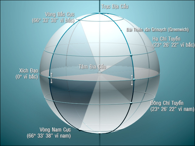
There are 5 special latitudes on Earth. The four latitudes are defined based on the relationship between the Earth's angle and its orbit around the Sun. The fifth, equatorial, is between two poles. They are:
- Arctic Circle (66 ° 33 '38 "north latitude)
- Lower Tropic of Cancer (23 ° 26 '22 "north latitude)
- Equator (north latitude 0 °)
- Eastern lice (23 ° 26 '22 "big south)
- Antarctic Circle (66 ° 33 '38 "big male)
The Tropic of Capricorn and the east of the Tropic of Capricorn are the northern and southern boundaries of the land on Earth that can see the Sun passing through the top of the head at least for a time of the year. The north pole and the south pole are the boundary of the region around the Earth's pole where the Sun can be seen at least one mid-summer day of the year.
The latitudes are the wrong paths, but except for the equator, they are not large circles, and therefore do not contain arcs as the shortest distance between points, as opposed to what is seen on some maps. where they are drawn in straight lines. The flights on the northern hemisphere between points of the same latitude will follow the shortest path that looks like a curve to the north on the above maps.
The arcs on the Earth are sometimes used as borders between countries and territories. Some latitudes are used as borders:
- The border between Canada and the United States is almost entirely on the 49th parallel north, except for the part between Québec and Vermont on the 45 ° north latitude.
- The 38 ° north parallel is used to divide Korea and South Korea.
- The 17 ° north latitude is used to divide Vietnam by the Geneva treaty.
- The 60 ° male parallel is used to delimit the border for Antarctica
The current Earth has 181 parallel lines (including the equator as a special latitude).
How to determine latitude and longitude on the map
Open the map or turn a circle of Earth model globe, you can detect, on the surface of the globe are the horizontal and vertical lines with a general rule, some are straight lines, some are curves, This road is called the latitude and longitude .
Their great use only if we can define meridians and latitudes can conveniently represent any location in any area. Especially when the plane flies over the vast sea or in the desert or through the jungle, if you want to determine the current location correctly, you must rely on meridian lines and latitude lines.
So how are meridians and latitudes?
We already know the Earth moves around the Earth's axis. The Earth's axis, this is a hypothetical line that connects the north and south poles and through the center of the Earth, if we are somewhere on the Earth's half axis and create a plane perpendicular to the Earth's axis, It is like cutting a watermelon into two parts, each of which is the Northern hemisphere and the Southern hemisphere, the interface between this plane and the Earth's surface is a very large circle, it is the largest circle on The Earth is called the largest latitude ring, in geography called the equator. So we can shift towards the North and South pole, on the map there are many lines parallel to the equator, these lines are called latitudes. We consider the equator in the latitude 00, each direction South and North are 900. The equator goes southward called the South latitude , down to the North, called the North latitude , 900 North latitude is the North Pole, 900 degrees South is South Pole.
From the North Pole to Antarctica can draw a lot of circle, which is the meridian. But how the meridians are divided, at first there were many disagreements, from the beginning, all countries took meridian lines through their capital, 00, and considered the starting point to calculate. longitude. In 1884 the countries participated in the first international longitude conference held in Washington, which defined the meridian that ran through the observatory (Calini in the southeastern suburb of London England was the starting point). collectively, to calculate longitude lines all over the world, also determine longitude 00, also known as Ty Ngo Street, calculated from this road, toward the East and West are equally divided into 1800. Heading east is called East sutra, towards the West is called the West Sutra, so 180 0 East Sutra and 1800 West Sutras are in fact lying on a straight line, often called meridian 180 0. On the road map used to divide the change the international date, basically taking this line as a standard.
If you tell you the latitude of Beijing is 39 0 54 'North latitude, the longitude is 116 0 9' East longitude, so you can immediately find its location on the map.
There is a way to determine a latitude longitude of an area. Darkness, observing the number in the sky that the North Star is higher than the ground can outline the latitude of that area. For example, looking at the North Star in Beijing about 40 degrees north latitude, longitude can use local time difference compared to the world time to calculate, for example Beijing's earlier hours compared to the world time is 7h46 ', we know on Earth, the time difference is one hour, the difference is 45 0 difference. Therefore it can be speculated that Beijing's longitude is about 116.5 0 Dong.
- Bad things always remember longer than good
- The tropical region has been expanding since 1979
- The latitude time
- Memory loss because of biological clock disturbance
- 12 horrible things about China you may not know
- 10 interesting things about life you may not know
- 9 things are more important than money
- The higher the latitude, the bigger the brain
- Mercury, acupuncture method to cure many diseases
- 10 interesting things about nature you may not know
- Tonight 'sun tsunami' fell on the earth
- Women do many things at the same time better than men
 'Fine laughs' - Scary and painful torture in ancient times
 The sequence of numbers 142857 of the Egyptian pyramids is known as the strangest number in the world - Why?
 History of the iron
 What is alum?