Ecosystems of Southeast Asian countries viewed from satellites
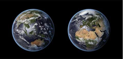
Artificial scenes are recreated by computers from images obtained from a geostationary satellite. These images are created by a remote sensing dataset, including MODIS true color images and weather information.

The exhibition called "Eye of the Sky" took place from 4 to 20 May, by the Department of National Information and Science (NASATI) under the Ministry of Science and Technology, along with the German Space Center (DLR). and the German Academic Exchange Agency (DAAD) organized. The exhibition aims to increase awareness of issues and challenges to the ecosystem on the earth. Viewers see the world through an artificial satellite, clearly seeing areas like the Danube flowing through 10 European countries, Ha Long Bay area, Southeast Asian tropical forests . All reflections the diverse and vivid development of different ecosystems as well as the problems that these areas are facing.

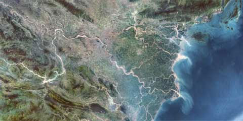
Hanoi and Ha Long Bay. In this image obtained from Landsat satellite, Hanoi is located in the middle, on the banks of the Red River. In the picture, the Red River and the Red River Delta are on the right, while the left is the Da River with the hydropower plant and the reservoir in Hoa Binh. This river system has created fertile agricultural lands. North of the Red River Delta is Ha Long Bay, a famous tourist destination in Quang Ninh province.

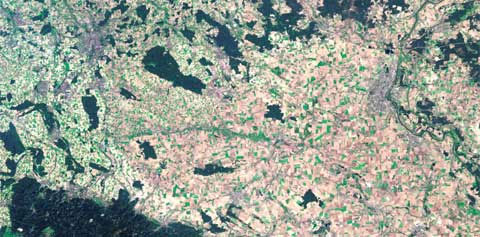
The difference in agricultural practices between West Germany and the former German Democratic Republic (GDR) is clearly evident in the picture taken by Landsat satellite in September 1999. 10 years after reunification, the old boundary area is still very visible on the picture by different forms of land use. Different from the small fields in western Germany due to the custom of inheriting the land, the fields in eastern Germany are often very large.

Plastic sea, one third of Spain is under threat of desertification. The soil layers are degraded due to drought, erosion and salinity. Only the irrigation system of this semi-arid climate area can help with intensive farming. In the southern Mediterranean coast, about 20km south of Almeria, countless plastic roofing greenhouses appear in bright white. This region is called El Mar de Plástico, or Sea of Plastic. This is the largest vegetable and fruit greenhouse in the world, helping Andalusia province change its life. However, the decline and salinity of groundwater causes farmers to invest heavily in desalination and energy-consuming systems.

Natural heritage Danube plateau. This is the second largest river in Europe, flowing through 10 countries before pouring into the Black Sea (Black Sea). The Danube plateau located on the Romanian territory consists of three main regions and many small branches, reeds, islands and lakes, as well as riparian forest areas, and arid sand dunes. In 1991, UNESCO announced the Danube plateau as a World Natural Heritage.

City and harbor of Singapore. Not only is a major business and commercial center, Singapore is also an important regional education and research center.

Shrimp farming in Thailand. Due to declining catches, seafood farming has provided more than half of the seafood consumed. The aquaculture industry, such as shrimp, crab, fish, mollusks and algae, has become the fastest-growing biological industry in the last decades. The image depicts a typical diagram of a shrimp farm on the river near Amphoe Klaeng, the northernmost of the Gulf of Thailand, 100km west of the Cambodian border.

Major delta systems of Southeast Asia: Mekong and Irrawaddy. The Mekong Delta is on the left, very fertile and suitable for rice cultivation. On the right is Myanmar's Irrawaddy plain. With a length of 2,170km, Irrawaddy is Myanmar's largest river, passing through 9 branches of the Irrawaddy Delta, flowing almost through the country before reaching the Andaman Sea.

Images of forests in the Luzon Mountains of the Philippines are obtained from the Quickbird satellite showing some landslides along the Bontoc road - Banaue. Road construction is a major factor in landslides, but improved road conditions also contribute to stopping slopes. The forest in this area has a great biodiversity with many endemic species and a constant water supply for the famous terraced fields at lower slopes. These terraced fields are also part of UNESCO's cultural heritage.

Primary forest in Indonesia. Even in the forest area that seems to have not been invaded, satellite images still show human traces, such as riverbank settlers or logging operations. Indonesia has the second largest area of tropical forests in the world but is threatened by land change and illegal logging.

Images from Quickbird satellite show the coastline with the remnants of Malaysian mangroves. This area is mainly agricultural land and the mangrove belt here has also been interfered by human activities. Aquaculture such as shrimp farms and tourism infrastructure are also threatening the existence of mangrove forests here.

The picture shows the degradation of Laos forest, in the area of southwestern Champasak province sharing the border with Thailand and Cambodia. The vast Mekong flows through this province very clearly at the end of the photo. The ruins of the famous Wat Phou of the Khmer empire were discovered in the jungle a few kilometers away from the site. This picture records the transformation of tropical forests into cultivated land. With water and road systems and settlement activities, reclamation is gradually moving towards the forests. To the north of the highway, the center of the photo, this is still a system of primeval rainforest.
- Southeast Asian pythons slaughtered many small mammals in the United States
- Asian countries will launch a universal space satellite
- Southeast Asia will be the region most heavily affected by climate change
- Southeast Asian countries sink into the sea the fastest in the world
- Southeast Asia should learn Chinese technology strategy
- Asia: Towards cooperation in space research
- Japan supports Southeast Asian countries against flood and storm
- Southeast Asia is severely affected by climate change
- Introducing the world's largest tiger and tiger
- The idyllic beauty of Vietnam in Southeast Asia
- Indonesian wildfire is blackening the skies of Southeast Asian countries
- The first summit about the Mekong
 The 11 most unique public toilets in the world
 Explore the ghost town in Namibia
 Rare historical moments are 'colored', giving us a clearer view of the past
 The world famous ghost ship