Huge gravity hole under the Indian Ocean
Experts have found a possible reason why a 3 million km 2 gravity hole , where gravity is especially weak, formed in the Indian Ocean .
Deep below the Indian Ocean there is a giant gravity hole with a size of about 3 million square kilometers that has puzzled scientists for decades. Technically, this is not a hole by the traditional definition. But geophysicists use the term to refer to an area where the effects of gravity are much lower than average .
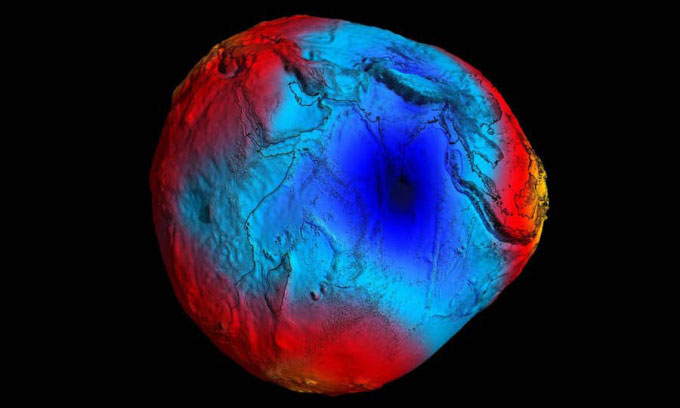
Map showing weak (blue) and strong (red) gravity places on Earth. (Photo: ESA/HPF/DLR).
The Earth is not a perfect sphere, the poles are flat, while there are bulges along the equator, so gravity also changes depending on location. Scientists have mapped these effects to create the Earth's "geoid" - a potato-shaped map that visually represents these valleys and gravity depressions.
If you look at a gravity map of Earth, you will see a giant blue spot over southern India, this spot is called the Indian Ocean Geological Low (IOGL) and is the largest gravity anomaly on Earth. our planet, has attracted the attention of researchers since its discovery in 1948.
This is the largest gravity anomaly on our planet.
Gravity anomaly is the difference between the actual gravity measured at a location and the theoretical gravity expected for a perfectly smooth and spherical Earth. But Earth's gravity is not completely uniform, and variations in mass distribution below the surface cause fluctuations in gravity.
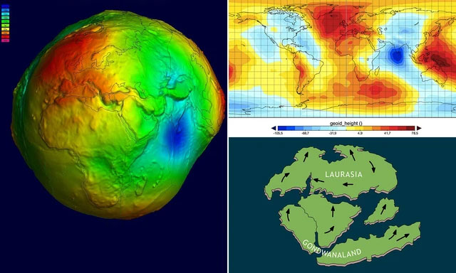
Gravity anomalies can be caused by changes in the density and thickness of the Earth's crust, mantle, and core. These anomalies affect the shape of the ocean's surface, which is not flat but follows the contours of Earth's gravitational field. This shape is called the Geoid, and it's what we would see if we removed all the effects of tides, winds, and currents from the ocean. The geoid is often visualized as a potato-like shape, with protrusions corresponding to high and low gravity zones.
In a new study published in the journal Geophysical Research Letters , geoscientist Attreyee Ghosh and graduate student Debanjan Pal at the Indian Institute of Science looked at the IOGL and discovered that the sea level of the surrounding ocean was nearly lower. 107m compared to the global average, Futurism reported on July 1.
After running multiple computer models of the region's changes over the past 140 million years, the team concluded that the IOGL could be the result of an "African lithosphere" - a giant mass of material in the layer Earth's mantle, located more than 965km deep under Africa - was pushed under the Indian Ocean.
Geologists believe that this mass of material formed from the undersea remains of the ancient Tethys ocean located between the two supercontinents Laurasia and Gondwana more than 200 million years ago. Then, about 120 million years ago, the Indian Ocean formed as Gondwana moved north into the ancient ocean.
According to Pal and Ghosh, the IOGL may have assumed its present form about 20 million years ago, when hot, thin magma flows surrounded the region, and plates of the Tethys ocean sank into the Earth's mantle.
However, according to expert Himangshu Paul at India's National Geophysical Research Institute, there may still be other factors behind the existence of IOGL. "Simulations will not be able to imitate nature exactly ," he said.
- Reveal the mysterious black hole on the Martian crater
- 10 fascinating facts about black holes
- Researching the 'dead sound' of black holes
- Water in the Indian Ocean flows into the Atlantic Ocean
- Huge volcano erupts from underwater
- Earthquake strikes the Indian Ocean
- Detecting huge hollow black holes in the universe
- Huge dead sea near Southeast Asia
- Gravity, gravity and things we still think
- Scientists split about the huge gap that appeared in Antarctica
- Hell hole in Russia Bermuda triangle decoding
- This is the surreal image of the black hole in the universe
 Surprised: Fish that live in the dark ocean still see colors
 Japan suddenly caught the creature that caused the earthquake in the legend
 A series of gray whale carcasses washed ashore on California's coast
 Compare the size of shark species in the world