Some unique frames about the earth viewed from satellites
We still often see pictures of Earth from satellites or spacecraft, but the images below will show you a different picture of where we live daily from many other locations. together.
It is the Bay of Bengal, Chernobyl before and after the nuclear explosion, shrimp field in Vietnam, volcano . The images you see below are extracted from 150 images in the book "Earth from Space" (Earth from space) by Yann Arthus-Bertrand.

Itaipu Dam, the border with Brazil-Paraguay: This is a famous water dam across the 1350km square along the border of Brazil and Paraguay.It has a duty to prevent water from entering, a place for agricultural development.

Sundurbans, West Bengal / Bangladesh, India: The Sundurbans in the Bay of Bengal is famous for its mangrove trees, it covers an area of about 10,000 square kilometers.This is the habitat of many rich flora and fauna including soft-haired otters, 260 species of birds, deer, wild boars, and crabs . In addition, some species are in a state of extinction as Indian crocodile, python or Bengal tiger.

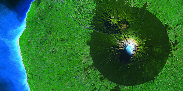
Taranaki volcano, New Zealand: A very clear picture of the different areas of Taranaki volcano in Egmont National Park.We can clearly see the ravine, the volcanic slopes and the surrounding areas.This circle has a radius of 9.6 km, with a volcanic height of 2518 meters and has been inactive since 1755.

Mount Hoggar, Algeria: Mount Hoggar in the south of Algeria, in the territory of Tamanrasset province.It includes volcanic rocks, lava flows and extinct volcanoes.One of them has a height of up to 3000 meters.

The Ebro River Delta, Spain: The Ebro is a river of over 900km in Spain, which empties into the Mediterranean and forms an Ebro river delta.The rich silt and canal system used to irrigate rice fields with products are very popular round grain rice (bomba rice).

Ordos Desert, China: Ordos Desert consists of steppe and desert on an area of 90,000 square kilometers.The land here is very dry because there is no Hoang Ha River flowing through.

Florida Keys: This is an archipelago with more than 1000 large and small islands and corals.Some small islands here are uninhabited and covered by mangrove trees, some of which are sometimes submerged by storms, partly due to global warming.In addition, fragmented ecosystems are threatening more than 250 bird species here.

Mount Everest, Nepal: Everest is the highest mountain in the world with an altitude of 8848 meters, once conquered by humans in 1953.

Dasht-e Kavir, Iran : This is a picture of two large Iranian deserts covering most of the central plateau of the country.This sand desert is 800km long and 300km wide, it is well known for its sand marshes or "Kavir".

Bac Lieu, Vietnam: The Mekong Delta concentrates many aquaculture areas, especially shrimp farms.However, these shrimp and fish farms are seriously polluting the environment from nitrogen gas, using antibacterial, hormones and other toxic substances.

Chuquicamata mine, Chile : This is an open-pit mine 2km wide, 3km long and 800m deep, one of the world's largest mines of copper reserves.Mine blasts and mine trucks have created toxic clouds for human health.All miners here are only allowed to work within 3 years and are at risk of lung cancer.
- Extremely rare video about 24h on Earth seen from the universe
- World of 2008 viewed from satellites
- Amazing earth images viewed from satellites
- Vietnam satellite will enter space in 2018
- India successfully launched seven satellites into orbit
- News aggregation or week 2/10
- The camera flashes at a speed of 10 million frames per second
- Thousands of satellites on Earth orbit can crash into each other
- Chinese artificial satellites provide images of the earth
- SpaceX brought two satellites to monitor the Earth's water level on the universe
- Vietnam will produce satellites in 2022
- Earth through satellite images
 The 11 most unique public toilets in the world
 Explore the ghost town in Namibia
 Rare historical moments are 'colored', giving us a clearer view of the past
 The world famous ghost ship