The disaster of dam failure in the United States from space
NASA shared photographs from the Landsat 8 satellite documenting the moment of water at the Edenville and Sanford dams on the Tittabawassee River, which flooded Michigan.
On May 17, heavy rains hit Saginaw, Bay City, and Midland cities in central Michigan. After two days, the rain caused severe flooding in Midland County. The accumulated rainfall caused the dam failure , causing river water to overflow and inundate some nearby residential areas. Michigan Governor Gretchen Whitmer issued an emergency evacuation order for more than 10,000 residents in Edenville and Sanford.
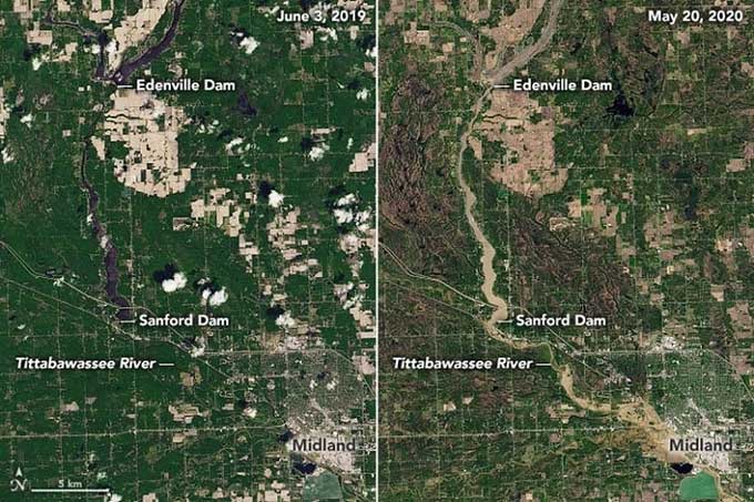
The Tittabawassee River before and after the flood. (Photo: NASA).
Natural-color photographs of the Midland County flood were taken by the Operational Land Imager (OLI) device on the Landsat 8 satellite of the US Geological Survey. The photo above captures the Tittabawassee River on May 20, 2020 (right) compared to June 3, 2019 (left). The photo below has a wider view, including the location of Edenville and Sanford dams.
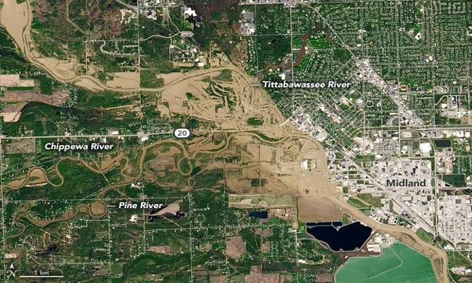
Floodwaters swept away mud and flooding in central Michigan. (Photo: NASA).
The National Meteorological Agency recorded a record rainfall of more than 10 centimeters in many places in Midland in 48 hours. The Edenville Dam then collapsed on the evening of May 19, causing floodwaters to flow south. About an hour later, water overflowed the Sanford Dam dam, flooding the Tittabawassee River and surrounding area. On May 20, the water level of the Tittabawassee rose more than 11 m, about 1.2 m higher than the flood in 1986. Governor Whitmer was forced to declare a statewide emergency.
- Historic snowstorm on the East Coast of the United States via satellite images
- New US space policy
- The UN uses space technology to manage the planet
- Japanese radiation detection off the west coast of the United States
- Liver failure: Causes, symptoms and precautions
- The broad and serious impact of air pollution in the United States
- Tornadoes make dozens of casualties in the United States
- American trees die faster because of climate
- The unfortunate incidents of space travel in history
- Disaster management for the Lower Mekong countries
- Russia and the United States cooperate to find water on Mars and the Moon
- November 20, 1998 - The first module of ISS International Space Station flies into space
 Van Allen's belt and evidence that the Apollo 11 mission to the Moon was myth
 The levels of civilization in the universe (Kardashev scale)
 Today Mars, the sun and the Earth are aligned
 The Amazon owner announced a secret plan to build a space base for thousands of people