Announcing the map of Cao Bang natural radioactivity
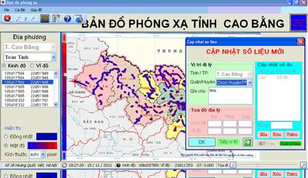
Scientists at the Center for Nuclear Physics, Vietnam Academy of Science and Technology have released a digital map of natural radioactivity on Cao Bang terrain. The map is updated with natural radioactive data of more than 6,000 points in 12 districts in the province.

Interface of radioactive map software in Cao Bang province. (Sapphire)
On the map, the points with radiation font data are represented by colored points that are colored. The numerical value of the data at the measured point can be viewed online by right-clicking on the measurement point on the map. Then the values will be displayed on the instant screen including: longitude, latitude and radiation dose rate at this point in microSv / h units. The map allows viewers to view the radiation map of the whole province or see only the data of a certain district.
According to author Le Hong Khiem, on the basis of available data, management agencies can easily compare natural radioactivity fonts at different times to soon adjust.
According to the Institute of Nuclear Science and Technology, currently there are only a few localities with natural radiation maps of Hai Duong, Thai Binh, Quang Tri, Hue, Vinh Phuc, Phu Tho and Quang Ngai.
- Detecting some residential areas with high radioactivity
- Planning for conservation of Phong Nha-Ke Bang National Park
- Build an introduction area for Phong Nha-Ke Bang in Germany
- Announcing the new worm frog
- More Cao Bang province has bird flu
- Discover the first evidence of the Big Bang big bang
- Radioactivity in the air in Hanoi tends to decrease
- Found many relics of prehistoric people in Cao Bang
- Radioactivity in Tokyo does not come from Fukushima
- 8 interesting facts about Son Doong cave
- Unexpected information about the galaxy merged after the Big Bang
- The universe was born before the Big Bang?
 Vietnam 5th Asian champion on fuel-efficient vehicles
 We can read all NASA studies completely free of charge
 Singer and songwriter Bob Dylan won the 2016 Nobel Prize for Literature
 Scientific revolution in Asia