Decoding the mysterious geological structure in America
Researchers were able to clearly observe the mysterious geological structures in the US thanks to a continental scan.
The Discovery News page reported that a North American scan helped researchers to clearly observe the mysterious geological structures deep in the ground.
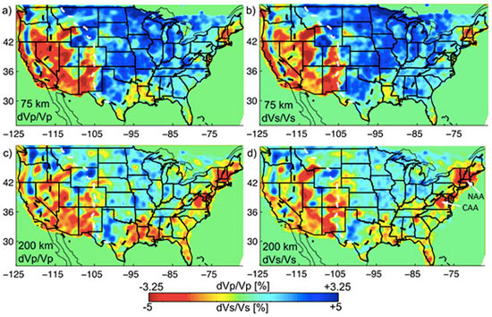
The scan is the result of a project called EarthScope, which began in 2004, with the aim of scanning geological images of the entire United States, from California to Maine, using hundreds of seismic measuring devices. The scan revealed new geological information of the western and central US, including the volcanic eruption shape of Yellowstone volcano.
The sweep of North America helped researchers decipher strange geological structures.(Photo Discovery News)
The EarthScope project conducted Earth tomography with a team of experts moving extremely sensitive seismic sensors on the ground, then researchers will conduct construction of images of lateral layers. below.
A seismologist, Brandon Schmandt of New Mexico University in Albuquerque, and his colleague, Fan-Chi Lin, who is working at the University of Utah, Salt Lake City, USA, created a copy. Detailed 3D map of the upper mantle (the rock layer between the Earth's crust and the Earth's core), enabling researchers to decipher the mysterious geological structures beneath the Earth's surface.
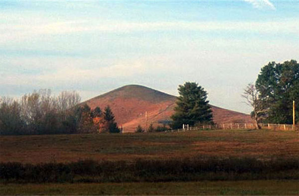
Unusual volcanic geological structures in Virginia have also found answers.
One of the questions that has caused geologists to learn about headache is why there are so many 48 million year old volcanoes formed in Virginia, while there is no other form of eruption that is shaped. into the East Coast region about 200 million years ago. East Coast is a passive coastline and does not occur tectonic plate collisions, but volcanoes still form abnormally in Virginia. Finally, the answer to this unusual geological structure may be due to the underground mantle, after researchers discovered that the mantle in this area was not as cold and dense as they were. think.
In addition, new data also showed the possibility that a part of North American land had been separated in the past, then replaced by a drift piece, possibly an island in a chain of islands similar to Japan. The drifting debris of the islands or other continents after connecting to North America has a hotter mantle than the original continent.
Researchers were able to better understand the geological structures deep down North America.
Some of the most obvious shapes in the newly created mantle map are ancient traces. Previous studies have shown that there is a 'graveyard' of fragments from the ancient ocean floor lying deep beneath North America. These oceanic shells converge in an area known as submerged zone located off the coast of West Coast. Here the process of sinking the plaques down into other plaques and sinking into mantle.
However, the sinking pattern of ocean plates is not the same as what researchers once knew. The researchers discovered fragments of an ancient oceanic shell fragment at a depth of 500 km below central and eastern America, while younger fragments of the oceanic crust were discovered in degrees. deeper than 1000km in the western United States. This led to the possibility of shrinking ocean shells from about 40 million years ago broken into pieces, of which two were known to researchers.
- Answer the mysterious structure in the Amazon forest
- Detecting strange convex spiral structures on Mars
- Mysterious structure under the Israeli sea
- Mysterious super-precarious rocks in America
- The first successful decoding of the wheat genome structure
- Super UFO structure discovered in Australia sky
- Mysterious stone structure 70 meters in diameter under Israeli sea
- Uncover mysterious figures in China
- Decoding the world's longest-lived human gene
- The mysterious 'Pyramid' in Indonesia
- The mystery has no answer in the Sahara's eyes
- Decipher the mystery of the Earth's inner core
 History of the iron
 The sequence of numbers 142857 of the Egyptian pyramids is known as the strangest number in the world - Why?
 'Fine laughs' - Scary and painful torture in ancient times
 Himba tribe has topless women in Africa