Ever had a civilization in Antarctica?
A map dating back to the 16th century accurately redraws the northern Antarctic coast, but when it has never been covered by ice. How can people know this continent at a time when they have no modern measuring tools like today? Did an ancient civilization do that.
Will there exist an ancient civilization in Antarctica?
The existence of prehistoric civilization in Antarctica began to be of interest to historians after World War II. This hypothesis can be demonstrated by medieval maps and numerous studies by geological and geological experts.
In January 1820, Captain Mikhail Lazarev of the Russian Royal Fleet explored the new continent. At the beginning of the 20th century, the famous Russian encyclopedia Brockhaus and Efron has written a heading about Antarctica, in which the continent has not been fully surveyed and has no flora and fauna.
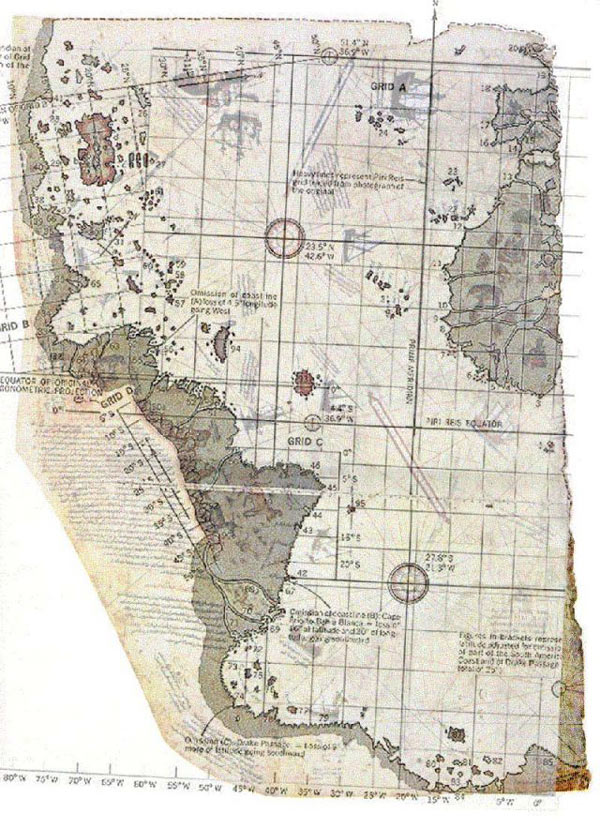
Map of Piri Reis, indicating South America, northern Africa and the north coast of Antarctica.(Photo: World-mysteries)
In 1929, the head of the Istanbul National Museum, Halil Edhem, found an ancient map painted on antelope skin while reviewing the library of Byzantine emperors . The author described the map very carefully. North African sea, south of South America and the northern coast of Antarctica. Halil was surprised at this discovery. He saw on the ice map Queen Maud Land at the 70th parallel there was no ice, but instead was a mountain range . The name of the author of this map was no stranger to Edhem. It was Admiral Piri Reis , of the Ottoman fleet, who lived in the first half of the 16th century.
The strange thing is not only how can Admiral Piri Reis accurately map the Antarctic region 300 years before it was discovered, but the question focuses on why the map can be shown. The South Pole since this region has not been covered by ice. Piri explained on the sidelines of the map that he had relied on many previous sources of literature, some of which belonged to his era, others from a farther age, around the 4th century BC. One of these documents dates back to Alexander the Great . According to Reis's map, the coastal part of the continent did not cover ice.
In 1949, a British-Swedish joint expedition team conducted the southernmost exploration of the continent through a 1.6-kilometer thick ice sheet. The results confirmed the map showing the land of Queen Maud Land with absolute accuracy compared to the seismic measurement data. This proves that this coastline has been mapped before being covered by ice.
The coincidence is that the Piri Reis map is also drawn according to the method of locating meridians and latitudes . But historically, the first map of the earth by this method was drawn by Englishman John Harrison in 1761. Is it more than 6,000 years ago that the earth was known to be spherical?
Orthodox science has always argued that the ice covering Antarctica is 1 million years old. With the whole northern part of the continent being displayed like this before the ice covered, it can be deduced that the map was drawn from 1 million years ago, but this is difficult to explain, because then people were not yet present. So is the Piri Reis map made from a civilization product that we never knew ?
In his 1979 book, The Map of Ancient Oceans , Professor Charles Hapgood identified the map Piri Reis as a source of material from maps of Minoans and Phoenicians , ethnic groups with many excellent navigators. . The maps they drew were kept in the library of Alexandria and Constantinople. During the 4th Crusade in 1204, those maps were transferred to Europe. According to Hapgood, among them are maps of the Americas, Antarctica and the South Sea. It is amazing that the ancient people could draw Antarctica when it had never been frozen. And it becomes fascinating because how they can measure accurately on the map so much.
From the story of the Piri Reis map, it is hypothesized that there were disappearing civilizations along with a relatively high level of technological development. In 1953, a naval officer sent this map to the US Army Map Research Center. The center's chief engineer and researcher of the ancient map of Arlington H. Mallery measure and compare Piri Reis with modern maps. They came to the conclusion that this map has absolute accuracy that can only be used by satellite positioning to measure it. So who drew the map 6,000 years ago to use Piri Reis as the basis for drawing his map?
There is a theory that between the 5th and 10th millennia BC, a human civilization once existed on the planet. People at that time possessed great knowledge of navigation, studying maps, astronomy . with a level no less than the 18th century civilization. mankind created not alien It may start on the northern coast of Antarctica or in the islands of the continent, which had a temperate climate at the time. After that, this civilization could encroach on the northeastern continent of Africa.
This unknown civilization may have disappeared due to the encroachment of ice, beginning in the 10th millennium BC. Another reason for this disappearance may be the deluge that leads to prolonged flooding. Such natural disasters can devastate the entire early civilization.
- Redefining the age of Indian civilization
- Civilizations of aliens?
- Mysterious ancient civilizations unknown
- Beams: interesting Antarctica
- Antarctica - 'fire hell' between the earth in the coldest place in the world
- The levels of civilization in the universe (Kardashev scale)
- Strange civilizations were accidentally forgotten by humanity
- Antarctica is warming up
- Highway legendary ancient city under 800m Antarctic ice?
- Ice melt record in Antarctica
- Ancient civilizations were forgotten
- Decipher the collapse of the first ancient civilization
 Discovered an ancient centipede fossil 99 million years old
 Discovered bat-like dinosaurs in China
 Discovered a 200-year-old bronze cannon of the coast
 Discover 305 million-year-old spider fossils