Flash floods cause heavy damage but why can't early warning?
Flash floods are increasing both in frequency and intensity and destructive power in our country, not only in mountainous areas but also in coastal areas. However, the forecast and warning are not timely and accurate.
No early and accurate flash flood forecasting
According to Prof. Dr. Le Huy Ba, former Director, Institute of Natural Resources and Environment Science, Ho Chi Minh City University of Industry, flash floods are phenomena of hydrology resonating with erosion, landslides, especially dangerous when There is a large amount of water concentrated on the slope, creating a flow with high velocity flowing downwards, it will sweep and destroy all obstacles on the way.

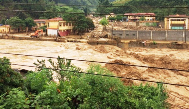
Flash floods cause serious damage in Muong la district, Son La province.
Flash floods occur abnormally, unexpectedly, very quickly. Flood peaks usually appear 3-4 hours after the start of rain, only 1/3 or 1/4 of the normal flooding time. Although it happened in a short time, due to the unusual and intense nature, the flash flood left serious consequences. Therefore, it is difficult to use the existing common methods in calculating hydrological forecasts to forecast and warn of flash floods early and accurately . In particular, flash floods are not only present in mountainous areas but also in coastal areas, where there is a high slope and have a surface layer of loose materials, and the lower soil layer is less permeable than in the Central region. .
According to experts on meteorology and hydrology, Vietnam is located in the tropical monsoon climate, suffering many bad impacts of the weather. Northern mountainous provinces such as Ha Giang, Tuyen Quang, Dien Bien, Son La ., provinces in the Central Highlands such as Dak Lak and Lam Dong; Provinces in the South East region such as Binh Phuoc, Tay Ninh, Central mountainous provinces such as Thanh Hoa, Nghe An, Ha Tinh, Quang Ngai are provinces with high risk of flash floods.
Map the zoning of flash flood risk
Prof. Le Huy Ba showed us the results during his time with his colleagues to experiment, collect data, investigate natural characteristics and socio-economic conditions related to flash floods in some provinces such as Dak Lak, Quang Ngai, Binh Phuoc . He said, the research team used the method of GIS geographic information system and remote sensing technology, established a map of flash flood risk zones in the province and key areas point.

A flash flood in Mu Cang Chai, Yen Bai.
Applying a review in the area of 7 districts of Dak Lak province such as Ea Hleo, Krong buk, Cu Mgar . shows that the factors of surface buffers, land cover and geological surface are easy to change, especially in recent years. the exploitation of primary forest, the area of afforestation is not enough to cover the area of exploited forest, reclaiming production land not in accordance with the planning, the system of irrigation works is not safe.
In Quang Ngai, according to survey data, in the past 30 years, there have been about 45 flash floods in the province. In a year, the Tra Khuc dike system was broken, making Quang Ngai town 8.82m deep. The reason is that the general topography of the province is a small delta associated with the river mouth, lower than the surrounding terrain, exploiting and using land arbitrarily, deforestation to grow agricultural and industrial trees, causing soil erosion .
Environmental impacts of flash floods cause erosion, make soil layers washed away, degraded resources, polluted surface water and groundwater, affecting terrestrial and underwater ecosystems . Flash floods as streams flowing fundamentally changes in substance. Especially affecting human life, property damage, and increasing epidemics.
According to experts, mapping out identified, delineated areas of flash flood risk, proposed solutions to prevent and limit the harmful effects of flash floods is necessary. Data for implementing flash flood forecasting and warning processes include data on meteorological and hydrological changes in the basin and river. Status characteristics in the basin such as area, slope, topography, land, vegetation, erosion. Data on rain cause flood, loading, evaporation, permeability, moisture. When there are weather events such as storms and tropical depressions, immediate attention should be paid to precipitation and preceding data .
Early warning and forecasting are seen as an especially important measure among effective non-structural measures for flood prevention and landslide.
- Instructions on how to get rid of safe flash floods
- Flooding scene devastated 12 dead in Sapa
- Large floods in India and Canada cause great damage
- Lam Dong: floods caused 2 deaths
- What are flash floods? Where do flash floods occur, when?
- Heavy floods caused heavy damage in Lao Cai province
- The North and Hanoi continue to have heavy rains, Yen Bai and Lao Cai are at risk of flash floods
- Making 26 people dead and missing in the Northwest, flash floods continue to threaten the Northeast
- Nghe An: Big floods suddenly, people are miserable
- Flash floods in the Philippines: 650 deaths, 800 missing
- Flash floods caused 1,600 people to evacuate urgently in France
- This afternoon, Bac Bo had heavy rain, the risk of flash floods in the mountains
 Is the magnetic North Pole shift dangerous to humanity?
 Washington legalizes the recycling of human bodies into fertilizer
 Lightning stone - the mysterious guest
 Stunned by the mysterious sunset, strange appearance