Google cannot end the rumors about the legendary city
The online community is excited when an engineer finds Google Earth 5.0 images of horizontal lines like street maps. Google rejected the hypothesis of Atlantis's remnant, but many believe it is "trying to hide something."
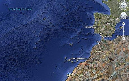
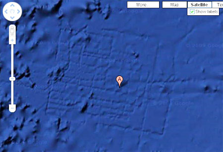
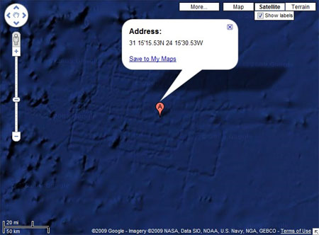
During the Google Ocean discovery, the new feature of Google Earth earlier this month, Bernie Bamford, 38, discovered strange lines, about the size of Wales, near Canary Island in the Atlantic Ocean. That image was quickly analyzed by netizens and affirmed to be the legendary land of Atlantis that the ancient Greek philosopher Plato described.
According to Plato, this "civilized and rich" city sank under the sea after the 9,000 BC earthquake and flood. Atlantis appeals to the public's curiosity for centuries, though archaeologists have not been able to prove whether it is real or just a product of imagination (like "lost continent" MU).
In recent years, traces of Atlantis have been found on the coast of Cyprus and in southern Spain. Dr. Charles Orser at New York University (USA) said that exploring Google Ocean is very interesting and worthwhile to learn more.
However, a Google representative explained the lines created by the ships surveying and measuring the ocean bottom. Moreover, the city that Plato mentioned was constructed in an arch, instead of a rectangular grid.
But on many forums, members "felt shady signs in Google's answer". The way they were interested in this event proved that many people believed that Atlantis was completely real.
- New hypothesis: The legendary city of Atlantis lurks in the heart of the Sahara desert
- The legendary city rises from the deep grave
- Revealing the legendary underwater city of Egypt
- Spot the legendary city of Atlantis
- Find the legendary city of civilization that has mysteriously disappeared?
- 'Find the legendary city of Atlantis'
- Atlantis disappeared on Google Earth
- Mysterious legends about the legendary city of Atlantis
- Discovering the city 'alien' thanks to Google Earth?
- The rumors are not true about flying
- Highway legendary ancient city under 800m Antarctic ice?
- San Francisco chose Google
-
 The truth about the mysterious red-haired giant at Lovelock Cave
 - Inunaki Tunnel: The haunted road leading into Japan's 'village of death'
- The mystery of the phenomenon of human reflection before dying
- 6 mysterious phenomena, although science has been developed for a long time, still cannot be answered
 The truth about the mysterious red-haired giant at Lovelock Cave
 Inunaki Tunnel: The haunted road leading into Japan's 'village of death'
 The mystery of the phenomenon of human reflection before dying
 6 mysterious phenomena, although science has been developed for a long time, still cannot be answered