NASA captures strange place on Mars: Is this a habitable zone?
NASA says the image was captured by the HiRISE satellite while flying above Danielson Crater, a geologically interesting crater.
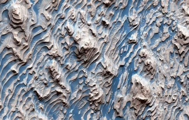
Interesting landscape in the photo NASA just released
Although the real landscape is not as beautiful blue as the image has been color-corrected by NASA, it can be clearly seen that the magical folds of the sediment layers are quite evenly spaced, with different degrees of corrosion. together.
The uniformity between these layers - despite being spaced out - suggests that they cannot be produced by random processes such as events and touches. Instead, something cyclical deposited the sediment.
These sedimentary rocks were formed millions and billions of years ago when loose sediments settled into the crater, layer by layer, and were cemented in place. Faults are created when sediment turns to rock.
According to Science Alert, NASA has two theories for the formation of this particular landscape: due to climate change caused by cyclic changes in Mars' orbit, or due to an aquifer.
The aquifer hypothesis is particularly interesting, because where there is water, there can be life. And Mars is one of the top targets in NASA's life-hunting journey.
- The strange cloud on Mars is sent by Curiosity
- Strange things in the land called
- Strange object resembles a mysterious ship on Mars
- Billionaire Elon Musk suggests reforming Mars with a nuclear bomb
- NASA's new Mars probe captures a detailed picture of the Mars Road Seeer's response in 1997.
- NASA deciphered the strange white light on Mars
- NASA tossed the clip of Martian water
- NASA robot captures drifting clouds on Mars
- NASA plans to 'eavesdrop' on Mars
- NASA explains strange images on Mars
- NASA has just taken a monstrous photo that looks like a fake about Mars
- NASA found the slab that could possibly contain life on Mars
 Announced 3 houses on the Moon and Mars
 Science proves: Mars also knows 'deflated'
 Elon Musk announced the price for a Mars trip was 11.6 billion VND, free of charge
 NASA discovered strange 'gate' on Mars, is the hiding place found?