NASA launched into orbit 8 micro-satellites that could predict the storm
At 9 am December 15 (US time) - 21 hours on the same day (Vietnam time), the US Aeronautics and Space Agency (NASA) successfully launched 8 ultra-small satellites that can measure wind in the heart of the storm and provide accurate information to help improve storm forecasting.
Each satellite weighs only 30kg and has a wingspan of 1.5 meters.

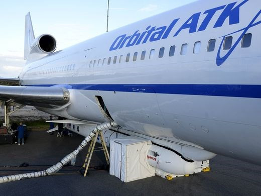
Aircraft carrying NASA satellite.(Source: Florida Today).
According to NASA's announcement, Stargazer L-1011 aircraft carrying the satellites took off from Cape Canaveral Air Force Base, state of Florida, USA.
An hour later, the plane's pilot pressed the Pegasus XL activation button and satellites from 11,800m above sea level and 160km east of Daytona beach.
Pegasus missiles are launched after 5 seconds, pushing the satellites toward orbit.
NASA said the global satellite navigation system is worth $ 157 million. These satellites use radio waves from the Global Positioning System (GPS) to measure the wind when storms pass through the ocean, allowing scientists to calculate the wind speed and intensity of a storm.
This satellite system can operate in stormy conditions and go deep into the storm center. This is considered a big step forward compared to current technologies.
- Successfully launched the micro-satellite of Vietnam
- India successfully launched seven satellites into orbit
- Russia launched three military satellites into orbit
- The world's first 3D printed satellite was launched from ISS
- New NASA satellites can predict droughts and floods
- Japan is about to launch a micro-satellite of Vietnam
- Thousands of satellites on Earth orbit can crash into each other
- More than 1,200 satellites orbit the next 10 years
- Russia launched two communication satellites into Earth's orbit
- NASA has successfully launched the SMAP satellite
- Found NASA satellite missing 12 years in the universe
- China launched two satellites into space
 Van Allen's belt and evidence that the Apollo 11 mission to the Moon was myth
 The levels of civilization in the universe (Kardashev scale)
 Today Mars, the sun and the Earth are aligned
 The Amazon owner announced a secret plan to build a space base for thousands of people