NASA satellite discovered Niagara Falls is polluted
Not only water, but also pollutants originating from forest fires thousands of miles away in Ontario, Canada, are polluting the Niagara Falls on the border between the United States and Canada. According to new findings recorded by NASA's Aqua satellite.
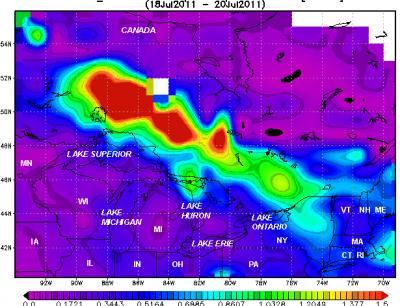
This image has been recorded by MODIS tool on Aqua satellite, from July 18 to July 20, 2011.
The MODIS tool on two NASA satellites showed two pollution points from fires in Ontario, Canada. The radiation spectrometer image provided by MODIS tool installed on NASA satellite and Terra satellites. The MODIS tool has provided a visible view of smoke and pollution that has spread across Niagara Falls, and east of Nova Scotia, Canada.
As of July 20, 2011, the Canadian Forest Fire Warning Center (CIFFC) noted that: Ontario, Canada, accounted for 40% of new fires nationwide during the week of July 17, 2011; In 2011, the State of Ontario, Canada, had more than 300,000 hectares of land, burned. Nova Scotia, Canada's daily news section, says smoke from fires has also spread to Nova Scotia and Newfoundland, Canada, by the end of the week.
NASA's Aqua satellite traveled through western Ontario, Canada, at 17:58 UTC (1:58 pm EDT), July 18, 2011, and captured images of light brown smoke emanating from The wildfire is spreading fast on the Great Lakes (5 large lakes between the United States and Canada). The MODIS tool also has the ability to identify and explore ' hot spots ' where fires are still raging.
Data from the MODIS tool also helps identify contamination. The data was compiled and used by NASA's Giovanni system, from July 18 to July 20, 2011. Data provides measurement of what is called ' Depth of Optical Aerodynamics (AOD) '.
The higher value of the measurement (AOD) means that there is a condensate contaminant (small pollutant sample is also produced by soot and smoke from the fire) in the air, and there is too little light Get through the atmosphere. A prominent amount of aerosols from forest fires and coal-fired power plants is sulfur dioxide (SO 2 ).
From July 18 and July 20, 20011, the largest pollution occurred, also known as the amount of condensate aerosols north of the Great Lakes. In a large area stretching from the north of the Great Lakes. Through a large area extending from Northeast Lake Superior to the west of Lake Huron, the highest measurement dust particle reached 1.5 molecules per cubic centimeter.
Giovanni is a web-based application: providing a simple and intuitive way to visualize, analyze, and access large amounts of data thanks to remote sensors that are not needed by earth scientists. must download the data.
' One of the advantages of Giovanni application is that it allows us to quickly implement daily data, obtained from MODIS ' tool , Dr. James Acker, an oceanographer working at the Translation Center. Goddard Earth Science Information and Data Service (GES DISC) has created a special portal for education. The GES DISC Center operates as NASA's Goddard Space Center at Greenbelt, Md. " By averaging the data, we can see the apparent level of smoke coming out of the fire, which can pose a health risk ," Acker said. ' The data of the measurement (AOD) also shows clearly defined where there is smoke, and distinguishes it from weather clouds. '
Dr. Acker presented the first wildfire smoke response experience at a teacher workshop in northeastern New Mexico, where air quality was largely unaffected by wildfires. Arizona, USA, nearly 300 miles away.
- The beauty of Niagara Falls paradise
- Niagara Falls shimmering colors at night
- Marvelous ice fall waterfall in record cold wave
- Beautiful waterfalls in the world
- The majestic Niagara waterfall admire changes color
- NASA's satellite moment falls to Earth
- What's hot new NASA satellite to communicate with Earth?
- The largest waterfall ever existed on Earth
- 10 most exotic waterfalls in the world
- NASA launches the most modern weather satellite to date
- 10 most majestic waterfalls on the planet
- The most heavily polluted cities
 Is the magnetic North Pole shift dangerous to humanity?
 Washington legalizes the recycling of human bodies into fertilizer
 Lightning stone - the mysterious guest
 Stunned by the mysterious sunset, strange appearance