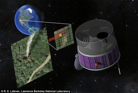
Satellite detection of forest fire
Researchers say they will design a type of forest monitoring satellite that can monitor the western United States. Through photos, it is possible to detect the occurrence of forest fires that have just occurred, thereby quickly transferring the means to extinguish before the fire is out of control.

Photo: Daily mail
From the University of California, Berkeley, scientists designed the geostationary satellite line to bring sensors, cameras and analytical software to control forest fires. The budget is several hundred million dollars and they hope to be funded by the government or private funds.
According to physicist Carl Pennypacker, the forest fire in 1991 devastated more than 3,000 homes in Berkeley and Oakland. Therefore, this type of surveillance satellite will help avoid similar disasters. Besides, he also commented that due to global warming, the possibility of forest fires will be more frequent and widespread.
The Daily Mail quoted Dr. Carl Pennypacker as saying that the satellite can be built and controlled by the federal government and private sector partners like the Landsat satellite program. It costs only a few hundred million USD but saves 2.5 billion USD that the national budget has to spend on fire fighting every year.
- Australia uses satellite information to track fires
- California sinks in 'hell fire'
- NASA captured the image of the big wildfire in America
- Nearly 100 hectares of Hai Van forest were destroyed
- New news of the biggest fire in Soc Son and Hanoi forests
- Shocking photos of the Amazon forest burst into record speed
- 44 people died, California forest fire has never been so horrifying
- The New York Times: Analysis of satellite images has pinpointed the culprit in the Amazon forest fire
- Terrible consequences of the Amazon forest fire
- The Amazon forest was big, and the smoke could be seen from the orbit
- Using fire to put out the fire like?
- Ha Tinh has forest fires, hundreds of people put out fires in the hot sun
 Van Allen's belt and evidence that the Apollo 11 mission to the Moon was myth
 The levels of civilization in the universe (Kardashev scale)
 Today Mars, the sun and the Earth are aligned
 The Amazon owner announced a secret plan to build a space base for thousands of people
 Artificial satellite missing for 40 years suddenly returns, leaving scientists bewildered
  What exactly is the space signal detected by Tesla?
  Satellite debris poses a serious threat to the atmosphere
  Declassified spy satellite, 1,400-year-old ghost town appears
  Britain's oldest satellite mysteriously moves
  Boeing satellite explodes in space