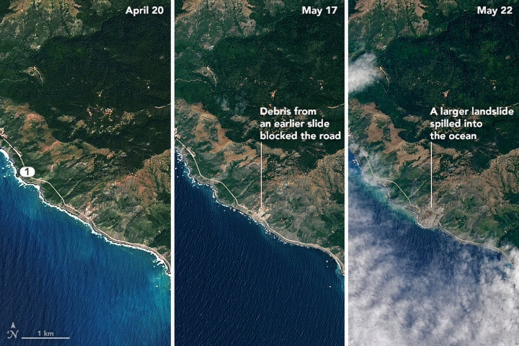
Serious landslide in California viewed from NASA satellite
A NASA satellite took pictures before and after a major landslide along California's Big Sur coast.
The landslide that happened on May 20 pushed about 1 million tons of rock and dust around the area around California's Highway 1 along the coast. Previously, there was a similar but smaller landslide earlier this year.

Images taken from NASA's Landsat 8 satellite show that a serious landslide swept away a large area around California's National Highway 1 into the sea.(Photo: NASA).
Thomas Stanley, a geologist and NASA researcher, said: 'This is a large landslide accompanied by smaller landslides, things like these are not uncommon. California's coastline is mostly prone to landslides, and fortunately the area where the landslide occurred is not inhabited. "
The landslide this time pulled a land area of 0.5 square kilometers and a volume of 10.6 to 13.7 cubic meters into the sea. After the landslide, it created 16 outcrops of land lying along the Big Sur coast.
The image of this massive landslide was captured by NASA's Landsat 8 satellite and the US Geological Agency. The previous image was taken on April 22, the next image captured a small landslide on May 17 and the last one was the aftermath of a massive slaughter on May 22.
This landslide caused California's No. 1 Highway to be blocked for a year. Currently there are still rocks falling into the sea and in the future, many similar landslides with small scale will still continue to take place.
- NASA announced a global landslide map, including Vietnam
- NASA's satellite moment falls to Earth
- What's hot new NASA satellite to communicate with Earth?
- NASA launches the most modern weather satellite to date
- NASA launches a new generation satellite
- Extremely rare video about 24h on Earth seen from the universe
- NASA satellite crashed into the Pacific Ocean and went missing
- This is how NASA will use it to protect chimpanzees
- Difficult to confirm satellite data, NASA asked for help from people around the globe
- American launch secret spy satellite
- NASA announces picturesque satellite imagery
- NASA reassured about dead satellite fragments
 'Fine laughs' - Scary and painful torture in ancient times
 The sequence of numbers 142857 of the Egyptian pyramids is known as the strangest number in the world - Why?
 History of the iron
 What is alum?