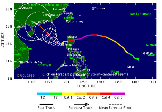
The northern provinces are affected by the southwest edge of the continental cold high pressure blade with a stable intensity and combined with the northern edge of the tropical convergence band with the axis going through the Middle Central connected to the storm Megi (digital storm 6) operating on the mainland east of Luzon island (Philippines).

The direction of super typhoon Megi.
Therefore, in many night and cloudy areas, there are rain in some places, noon in the afternoon, East wind to Southeast and Level 2 and Level 3.
Currently flooding on Nghe An rivers continues, rivers in Ha Tinh continue to fluctuate at high levels, Kien Giang River (Quang Binh) slows down.
Deep flooding in the river basins from Nghe An to Ha Tinh continues to be serious. In the mountainous area of Nghe An province, Ha Tinh needs to prevent landslides.
According to the Central Center for Meteorological and Hydrological Forecasting, at 4 o'clock on October 19, the position of the storm center number 6 is about 16.7 degrees Vi Bac; 118.7 degrees Kinh Dong, on the east of the East Sea.
The strongest wind is in the area near strong storm level 14, level 15 (ie 150 to 183km per hour), jerking over level 16.
It is forecasted that in the next 24 hours, the storm will move in the west every hour, about 15km.
Due to the impact of storms, the East Sea in the East Sea area has strong winds of level 9, level 10, then increase to level 11, level 12, the area near the center of the storm passes through level 14, level 15, level 17 waves. From 12-14 meters high, the sea is fierce.
The waters of Hoang Sa archipelago wind will gradually increase to level 7, level 8, then increase to level 9, level 10, shock level 11, level 12; The sea is very strong.
[#RelatedNews (10) #]
 Is the magnetic North Pole shift dangerous to humanity?
 Washington legalizes the recycling of human bodies into fertilizer
 Lightning stone - the mysterious guest
 Stunned by the mysterious sunset, strange appearance