The North faces dangerous weather patterns
The two storms simultaneously operating and the cold air rushing over made the North suffer from heavy rain from tonight. Rainfall of up to 300 mm in just 3 days puts the provinces at risk of flooding, landslides and flash floods.
In the afternoon of August 4, Goni storm continued to advance toward Leizhou Peninsula (China) with the wind sometimes jerking to level 11, the radius of dangerous wind is 150 km. According to the Central Center for Meteorological and Hydrological Forecasting, Goni will be weakened into a tropical depression when it enters the mainland.
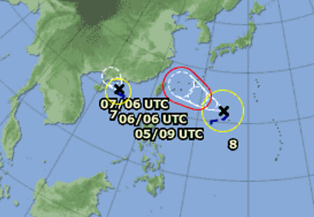
Strong storm Marakot (red-rimmed path) towards northern Taiwan is interacting and makes Goni's stormy path unpredictable.(Photo: JMA)
However, it is worrisome that the occurrence of a strong level 10 storm off the Pacific, international name Marakot and a wave of cold air rushing into the North West region. According to Le Thanh Hai, deputy director of the center, this is a dangerous weather pattern.
"Typhoon Marakot, although newly formed but very strong, has a wide range of influence. Its interaction with Goni caused changes in the weather, which is difficult to predict," Hai said.
Tonight, the rain will open in the northern provinces of Tonkin due to the influence of cold air. Around noon, 5/8 afternoon, weak tropical depression from storm No. 6 will start to cause widespread rain, lasting for 3 days. Many provinces in the North and the North Central region will experience total rainfall of 200-300 mm.
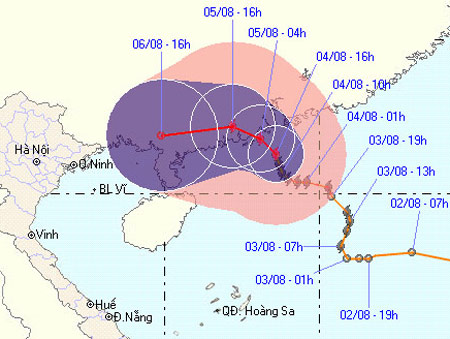
Goni complex path is also shown by the dense tracking newsletter of the Central Hydrometeorological Center.(Photo: NCHMF)
" The northern provinces in the coming days will be at high risk of flash floods, landslides and local flooding ," Hai said.
Regarding fishing vessels with 13 Quang Ngai fishermen caught by Chinese fishing vessels on August 1 when avoiding storms in Hoang Sa archipelago, Deputy Prime Minister Hoang Trung Hai asked the Ministry of Foreign Affairs to take the situation and intervene to soon bring ships and fishermen back to the country.
In the face of complicated weather, on August 4, Deputy Prime Minister Hoang Trung Hai chaired an online briefing with a series of northern provinces discussing response measures. According to the Deputy Prime Minister, with the evolution of the storm No. 6, it is necessary to monitor closely and inform continuously the owners of boats. The northern provinces noted to check the drainage system ready to cope with heavy rain.
In particular, to cope with the risk of landslides, the Deputy Prime Minister asked to immediately identify high-risk points, areas that are highly variable in terrain.
" These are places that can be detected early, need to be proactive to avoid the consequences like flash floods in Bac Kan last ", Mr. Hoang Trung Hai emphasized.
On August 4, the Central Steering Committee for Flood and Storm continues to send electricity to all northern provinces. Accordingly, the midland and mountainous provinces set up plans to prevent flash floods and landslides; plain and coastal provinces are ready to drain water, especially in big cities; actively responding to the situation of typhoon No. 6 continuing to change direction.
- Birds sing more flexibly when the weather fluctuates
- North: Sunny weekend 34 degrees Celsius
- Strange weather patterns on extraterrestrial planets
- The weather in the North turned cool
- Tomorrow the North is hot again
- The cold price still covers the North despite the sunny afternoon
- Weather today February 9, 2017: The North is cold and cold
- The north is hot again
- North and North Central Vietnam have foggy morning and afternoon sunshine in the afternoon
- This evening, the northern provinces have reduced heat thanks to showers and thunderstorms
- New weather technologies help keep the aircraft safe during thunderstorms
- Cold air causes dangerous rain and thunderstorms in the North and Central
 Is the magnetic North Pole shift dangerous to humanity?
 Washington legalizes the recycling of human bodies into fertilizer
 Lightning stone - the mysterious guest
 Stunned by the mysterious sunset, strange appearance