Three storms converge in northeastern East Sea
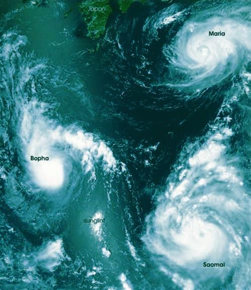
Aqua meteorological agency of the US Aeronautics and Space Administration (NASA) has captured a rare photo with three storms at once on the Pacific Ocean, northeast of the East Sea.
By means of an average resolution spectrophotometer on Aqua, a photo taken on August 7, 2006 showed that all three violent storms raged on a relatively narrow area in the Pacific Northwest. 'I have never seen such a phenomenon before,' said a meteorologist.

Satellite photo of 3 storms (Photo: TienPhong)
Looking at the photo, NASA experts analyzed, the storm Bopha in the middle of the left of the new image formed just a few hours before the shooting but was unable to develop further.
Meanwhile, Hurricane Maria in the upper right corner of the photo is reaching its strongest wind. In particular, the storm of Saomai is showing its strength three days after its formation.
At the time of photography, according to the Tropical Storm Information Center of the University of Hawaii, USA, Hurricane Maria had winds of 90-100 km / h (strong at level 9, level 10) while Saomai storms had winds of 140 km / h (above level 12).
Increasingly complex and fierce
Notably, the scenario that meteorologists predict that the storms of Bopha and Saomai may collide does not happen and, therefore, cannot form a new storm. However, while the Bopha storm weakened rapidly into tropical depression and faded away, Saomai became more aggressive.
By the end of the afternoon, 10/8 hours in Vietnam, according to the General Meteorological Bureau of China and quoted by Xinhua and Bloomberg, the area near the center of Saomai storm reached winds of 173 km / h, jerking at a speed of 209 km / h, level 17 equivalent.
Other figures say Saomai stormed 200 km / h and attacked eastern China last night after crossing northern Taiwan the same day. Nearly two million people in Zhejiang Province and Fujian Province were ordered to evacuate to avoid this rare super typhoon.
With the speed of wind showing no signs of decline, Saomai is heading to the east coast of China and becoming the strongest storm to attack the country since 2004.
That year, China was affected by Typhoon Rananim which killed 164 people and caused $ 2.3 billion in economic losses. But Typhoon Rananim at that time only had winds of 160km / h and was considered the strongest storm to attack China since 1956.
Thus, a commentary said, Saomai is the most powerful storm hitting China in the past 50 years
Typhoon Saomai was named as a super typhoon by the US-based Internet Weather Company and classified as the most powerful storm on the planet, a Category 5 storm.
With the phenomenon of three storms operating at the same time, the phenomenon of a storm weakens rapidly but has an abnormal path (Bopha moves down to the west-southwest), and one of the phenomenon The three storms of the triplets grew abnormally, the storms seemed increasingly complicated and fierce.
QD
- Danas storms level 10 toward the East Sea
- How was the storm in the East Sea formed?
- Tropical depressions intensified into storm No. 9, the North rained on a large scale
- News of storm near the East Sea: Melor storm
- Tin storm on the East Sea: Typhoon Khanun
- Typhoon Krosa is stronger and accelerates into the South China Sea
- Aere storm entered the South China Sea
- Typhoon Krosa threatens the Central
- The cause of sand storms raging throughout the Middle East
- A strong hurricane number 10 with level 12 approaches the land
- Strong storms appeared on the East Sea
- Strong tropical depression into storm No. 1, approaching the Vietnamese mainland
 Is the magnetic North Pole shift dangerous to humanity?
 Washington legalizes the recycling of human bodies into fertilizer
 Lightning stone - the mysterious guest
 Stunned by the mysterious sunset, strange appearance