Typhoon Kong-rey appears off the coast of the Philippines, unpredictable developments, new landfall location forecast
Storm Kong-rey - a storm forecast to become a super typhoon - is evolving unpredictably, changing direction suddenly and the location of its landfall is already known.
The latest storm information from the Philippine Atmospheric, Geophysical and Astronomical Services Administration (PAGASA) at 5:00 a.m. on October 28 said that Typhoon Kong-rey - the latest storm near the East Sea - still maintains its intensity but slows down its movement over the Philippine Sea.

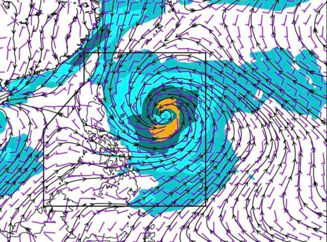
Storm Kong-rey is the latest storm right after storm Tra Mi - storm number 6 in the East Sea. (Photo: PAGASA).
The center of Typhoon Kong-rey (locally known as Leon) is approximately 840 kilometers east of Central Luzon, Philippines. The latest storm, following Typhoon Tra Mi - the sixth storm in the South China Sea - is moving west at 10 kilometers per hour, with maximum sustained winds of 85 kilometers per hour near the center and gusts of up to 105 kilometers per hour.
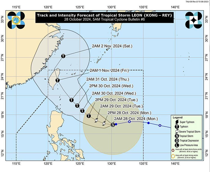
According to PAGASA's latest forecast, Kong-rey is expected to move westward for the next 12 hours before turning west-northwest early on October 29. Given the current movement of Kong-rey's path, PAGASA forecasters do not rule out the possibility that the latest storm near the Philippines will continue to move westward. Kong-rey may then turn northwest from October 30-31.
Typhoon Kong-rey is forecast to make landfall in Taiwan (China) early on November 1 before turning north-northeast into the East China Sea. The Japan Meteorological Agency (JMA)'s typhoon forecast model also predicts that the latest typhoon after Typhoon Tra Mi will also make landfall in Taiwan (China) on November 1.
According to the track forecast released by PAGASA, Typhoon Kong-rey is likely to pass near the Batanes region of the Philippines on October 30 or 31.

Forecast path of typhoon Kong-rey. (Photo: PAGASA)
Typhoon Kong-rey is expected to intensify over the next 24 hours and could reach severe tropical storm status this afternoon (October 28). Typhoon Kong-rey is also likely to intensify rapidly, increasing its intensity by at least 30 nautical miles (about 56 km/h) in a 24-hour period.
Previously, Typhoon Kong-rey entered the Philippine forecast area (PAR) at 7:30 p.m. on October 26. In the 4 p.m. bulletin of PAGASA on October 27, Typhoon Kong-rey was 1,000 km east of Central Luzon, with maximum sustained winds of 75 km/h near the center of the storm and gusts of up to 90 km/h as it moved west at 20 km/h. At that time, Typhoon Kong-rey was forecast to make landfall in the southwest of the Ryukyu Islands, Japan.
The latest forecast for Typhoon Kong-rey from the US Navy's Joint Typhoon Warning Center (JTWC) notes that the storm near the Philippines could reach its peak intensity on October 31, as a Category 3 storm on the Saffir-Simpson scale, with sustained winds of up to 205 km/h and gusts of about 240 km/h.
Also on October 31, Typhoon Kong-rey is forecast to turn north, towards Taiwan (China) and then turn east. The change in direction of Typhoon Kong-rey may be due to a developing subtropical high pressure and an ionospheric trough approaching southeast China.
According to typhoon experts, it is very rare for Kong-rey to make landfall in Taiwan (China) as a Category 3 typhoon. According to data since 1945, there have only been 3 typhoons that made landfall in Taiwan (China) as Category 3 typhoons in October: Nock-ten (2004), Longwang (2005) and Krosa (2007).
The latest storm report from Xinhua News Agency said that in response to Typhoon Kong-rey heading towards China, Fujian Province in the east of the country has activated a level 4 emergency response to Typhoon Kong-rey. Typhoon Kong-rey is forecast to strengthen into a strong typhoon or super typhoon by the National Meteorological Center of China.
- Typhoon Nida hit Hong Kong
- Super typhoon Haiyan is about to land in Philippines
- Typhoon Linfa entered Taiwan
- Typhoon Krosa threatens the Central
- Haima storm causes level 16 wind to enter the South China Sea
- Photo: Super typhoon Yutu caused heavy damage when landing in the Philippines
- The truth about Typhoon Ewiniar hitting the Philippines 8 times
- This afternoon, Typhoon Kai-Tak will land in the East Sea
- Adding super typhoon 240km / hour winds to Japan and Taiwan
- Tropical depressions appear into the East Sea, likely to become a typhoon
- Super typhoon Haima jumped above level 17, moving rapidly into the South China Sea
- The world's strongest storm hit the Philippines
 Is the magnetic North Pole shift dangerous to humanity?
 Washington legalizes the recycling of human bodies into fertilizer
 Lightning stone - the mysterious guest
 Stunned by the mysterious sunset, strange appearance