Use geographic zoning techniques to combat the spread of disease
A technique that often helps investigators delineate a serial killer's shelter, now this geographic zoning technique can help scientists stop the death caused by a base. certain infectious diseases.
The technique is very popular in criminal studies, called Geographic Profile Techniques , which help investigators narrow the scope of their search by accurately identifying high-priority goals among thousands of potential location. According to a study published in the Journal of Medical Geography, researchers have successfully applied the geographic file sorting technique: recognizing the recent source of malaria outbreaks in Cairo, Egypt. , and recreated a famous cholera outbreak in London, England. Putting this technique into the fight against the spread of deadly infectious diseases, can help focus the intervention of medical staff, can prevent the disease spread in the most economical way both in time. time and money.
" I think this technique has a lot of potential ," said Richard Ostfeld, an ecologist and pathologist, working at the Cary Ecology Research Institute, in Millbrook, New York, USA, " This is a Very interesting application of a Criminal Technique in combating the spread of plague ".
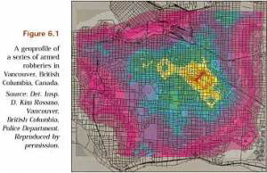
Geographic zoning helps determine the whereabouts of the culprit causing a series of armed robberies that occurred in Vancouver, British Columbia, Canada.
In the process of tracing criminals, how to arrange according to geographical records use the scene where the crime occurred as a springboard to visualize where the criminal can live. Pioneering in this area is Kim Rossmo, a criminal researcher, and a former police officer in Vancouver, Canada, currently working at Texas State University, San Marcos, USA. The method of sorting by geographical records is based on the tendency of the criminal to approach the blonde girl (victim), like when choosing a place to commit a crime, a position that is not too close to home, not too far, but moderate, according to Rossmo, a co-author of the new study, developed an algorithm that incorporates this view in two parts: The criminal is less likely to commit crimes in the buffer zone: those The neighborhood is close to home or work, because there are many risks found while there are too few chances of success, and there must be reasonable between crime scene and distance from the buffer zone, because Because moving requires time, effort and money.
" I work in London, " said Steven Le Comber, co-author of the study, working at Queen Mary University, University of London, England. " Because of that, I won't appear in Inverness (a remote land in Scotland) to kill people. But, I don't want to commit crimes too close to home ."
The arrangement according to the mathematical logic behind the technique of identifying geographic records is also closely linked to the idea that all distances are not created equal , moving on highways is easy. far more than the central area is always crowded. All of these measures are reconnected to create a map where offenders can live, covered on the map of the search area. Unlike geospatial techniques often specify a central point from which the search radiates outwardly, while the technique of identifying geographic records will help to indicate the potential location Most, even if they are at the ends of the search area.
Le Comber and his colleagues apply the technique of identifying geographic records to deal with a recent malaria outbreak in Cairo, Egypt. Of the 59 water samples with mosquito larvae found, only 8 samples contain the most dangerous malaria mosquito. Knowing the area where 139 cases of malaria have occurred, by geographic zoning techniques, it has been able to find exactly 6 out of 8 places with the most severe malaria.
" I have to say, this technique is really impressive ," Le Comber said. " It's too attractive ."
The team also used this technique on cholera outbreaks in London, England, in 1854, from which famous doctor John Snow created a map of people who died of cholera. This helps Dr. John Snow to discover that the disease outbreak is in Broad Street, and applies to areas of modern epidemiology. Based on 321 deaths, the technique for identifying geographic records also ranked Broad Street as the original source of most outbreaks, according to research results.
In some cases, such as secondary outbreaks, the technique of identifying geographic records may not be effective, Ostfeld said. But it can help bring more accurate maps to ecological questions, he said, such as how species can respond to climate change. Researchers used geographic zoning to study how sharks hunt and move bats and bees.
" This is a reciprocal relationship ," according to Ostfeld. "Molecular biology in particular has brought great benefits to the crime school ". For example, DNA identification, which arises from studies of evolution and genetic disease. " How great it is that a method is useful both ways, " Ostfeld said, " from biology to crime and vice versa ."
- Ancient Romans caused this terrible disease to spread and spread across the continent
- Scary scene when Ebola virus spread through the air
- How to prevent dengue in the community
- Combat Africa: Superhuman knife of World War 2
- Instructions on how to take care of lake orchid after Tet
- The disease spreads 'global threat'
- People in the Middle Ages had modern diseases?
- How do bats spread disease globally?
- Detection of flu in just one hour
- The US admits Ebola can spread in the air
- Murder can spread like infectious disease
- The fantasy world through the best photos honored by National Geographic
 'Barefoot engineer' invents a pipeless pump
 Process of handling dead pigs due to disease
 Radiometer
 Warp Engine: Technology brings us closer to the speed of light